Upper Saucon Township, PA
| Upper Saucon Township | |
| Township | |
|
Penn State Lehigh Valley campus
|
|
| Country | United States |
|---|---|
| State | Pennsylvania |
| County | Lehigh |
| Elevation | 833 ft (253.9 m) |
| Coordinates | 40°29′30″N 75°24′59″W / 40.49167°N 75.41639°WCoordinates: 40°29′30″N 75°24′59″W / 40.49167°N 75.41639°W |
| Area | 24.7 sq mi (64.0 km2) |
| - land | 24.7 sq mi (64 km2) |
| - water | 0.04 sq mi (0 km2), 0.16% |
| Population | 14,808 (2010) |
| Density | 483.9/sq mi (186.8/km2) |
| Timezone | EST (UTC-5) |
| - summer (DST) | EDT (UTC-4) |
| Area code | 610 |
|
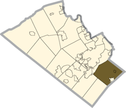
Location of Upper Saucon Township in Lehigh County
|
|
|
Website: www |
|
Upper Saucon Township is a township in Lehigh County, Pennsylvania, in the United States. It is in the vicinity of Allentown, Pennsylvania, in the Lehigh Valley region of the state, and geographically in the Saucon Valley.
Upper Saucon Township is home to The Promenade Shops at Saucon Valley which opened in 2006. DeSales University, Penn State Lehigh Valley, and Strayer University-Allentown campus are also located in the township.
According to the United States Census Bureau, the township has a total area of 24.7 square miles (64.0 km2), of which, 24.7 square miles (63.9 km2) of it is land and 0.04 square miles (0.1 km2) of it (0.12%) is water. Its boundary with Salisbury Township is located on Lehigh Mountain. Elevations range from approximately 500 feet in Spring Valley to over 1,000 feet at Bauer's Rock in Big Rock County Park. Upper Saucon is in the Delaware watershed and is drained by the Saucon Creek into the Lehigh River, except for a very small area in the extreme south just SW of Locust Valley, which is drained by the Unami Creek into the Perkiomen Creek and Schuylkill River.
Upper Saucon surrounds the borough of Coopersburg.
As of the census of 2000, there were 11,939 people, 3,970 households, and 3,283 families residing in the township. The population density was 483.9 people per square mile (186.9/km2). There were 4,117 housing units at an average density of 166.9/sq mi (64.4/km2). The racial makeup of the township was 97.11% White, 0.70% African American, 0.06% Native American, 1.13% Asian, 0.01% Pacific Islander, 0.40% from other races, and 0.59% from two or more races. Hispanic or Latino of any race were 1.07% of the population.
...
Wikipedia


