Upper Mississippi Valley
| Upper Mississippi River | |
|---|---|

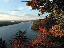
The Upper Mississippi River near Harpers Ferry, Iowa
|
|
| Country | US, Canada |
| Basin features | |
| Main source |
Lake Itasca, Minnesota 450 m (1,480 ft) 47°15′11″N 95°12′43″W / 47.253°N 95.212°W |
| River mouth |
Cairo, Illinois (flows into Lower Mississippi River) 37°00′47″N 89°10′49″W / 37.013144°N 89.180345°WCoordinates: 37°00′47″N 89°10′49″W / 37.013144°N 89.180345°W |
| Basin size | 490,000 km2 (190,000 sq mi) |
| Physical characteristics | |
| Length | 2,000 km (1,200 mi) |
| Discharge |
|
The Upper Mississippi River is the portion of the Mississippi River upstream of Cairo, Illinois, United States. From the headwaters at Lake Itasca, Minnesota, the river flows approximately 2000 kilometers (1250 mi) to Cairo, where it is joined by the Ohio River to form the Lower Mississippi River.
In terms of geologic and hydrographic history, the Upper Mississippi is a portion of the now-extinct Glacial River Warren which carved the valley of the Minnesota River, permitting the immense Glacial Lake Agassiz to join the world's oceans at the Gulf of Mexico. The collapse of ice dams holding back Glacial Lake Duluth and Glacial Lake Grantsburg carved out the Dalles of the St. Croix River. "The Upper Mississippi River valley likely originated as an ice-marginal stream during what had been referred to as the “Nebraskan” glaciation. Current terminology would place this as Pre-Illinoian Stage.
The Driftless Area is a portion of North America left unglaciated at that ice age's height, hence not smoothed out or covered over by previous geological processes.
Inasmuch as the Wisconsin glaciation formed lobes that met (and blocked) where the Mississippi now flows, and given that huge amounts of glacial meltwater were flowing into the Driftless Area, and that there is no lakebed, it is assumed that there were instances of ice dams bursting. Considering the history of Glacial Lake Missoula, something like this is believed to have happened.
...
Wikipedia
