Upper Marlboro, Maryland
| Upper Marlboro, Maryland | ||
|---|---|---|
| Town | ||
| Town of Upper Marlboro | ||

The Upper Marlboro courthouse under renovation in 2008.
|
||
|
||
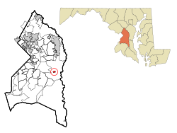
 Location of Upper Marlboro, Maryland |
||
| Coordinates: 38°48′59″N 76°45′12″W / 38.81639°N 76.75333°WCoordinates: 38°48′59″N 76°45′12″W / 38.81639°N 76.75333°W | ||
| Country | ||
| State |
|
|
| County | ||
| Settled | 1695 | |
| Established | 1706 (as Marlborough Town) | |
| Replatted | 1744 (as Upper Marlborough) | |
| Founded by | Kingdom of England | |
| Named for | John Churchill, 1st Duke of Marlborough | |
| Government | ||
| • Type | Commission | |
| Area | ||
| • Total | 1.11 km2 (0.43 sq mi) | |
| • Land | 1.04 km2 (0.40 sq mi) | |
| • Water | 0.08 km2 (0.03 sq mi) | |
| Elevation | 7 m (23 ft) | |
| Population (2010) | ||
| • Total | 631 | |
| • Estimate (2013) | 794 | |
| • Density | 609.1/km2 (1,577.5/sq mi) | |
| Time zone | Eastern (EST) (UTC-5) | |
| • Summer (DST) | EDT (UTC-4) | |
| ZIP codes | 20772, 20773, 20792 | |
| Area code(s) | 301 | |
| FIPS code | 24-79875 | |
| GNIS feature ID | 0598208 | |
Upper Marlboro, officially the Town of Upper Marlboro, is the seat of Prince George's County, Maryland in the United States. The population within the town limits was 631 at the 2010 U.S. Census, although Greater Upper Marlboro is many times larger.
Upper Marlboro was established in 1706 as "Marlborough Town", after John Churchill, 1st Duke of Marlborough, an ancestor of Winston Churchill. In 1744, the town was renamed to "Upper Marlborough". In the late 19th century, the town's name changed from Upper Marlborough to Upper Marlboro. The name change is linked to a postal clerk who felt that the last three letters, "ugh", did not properly fit on the rubber stamps being used at the time. By 1893, postal guides were referring to the town as Upper Marlboro and the name stuck, despite a proposed ballot to have it changed back in 1968.
The area of Upper Marlboro was first settled around 1695. It was named after John Churchill, 1st Duke of Marlborough, an ancestor of Winston Churchill. The land, which was to become the town, was part of several estates known as Grove Landing, Meadows, and Darnall's Chance, owned by the Brooke, Beall, and Darnall families, respectively.
Darnall's Chance, also known as the Buck House, was built between 1694 and 1712. The house can still be found across from the present-day County Administration Building on Gov. Oden Bowie Drive. It was owned by the Darnall and Carroll families. The home may have been the birthplace of Daniel Carroll, a signer of the U.S. Constitution, and his brother, John Carroll, the first archbishop of Baltimore, as well as the first Roman Catholic prelate in what would become the United States.
In 1706, Marlborough Town was established as a port town by the Act for the Advancement of Trade and Erecting Ports and Towns. It was declared that the town would be constructed, "at the upper landing on the Western Branch, commonly called Colonel Belt's landing." County surveyor Thomas Truman Greenfield conducted a survey of 100 acres (0.40 km2) of the three estates from which the town would be formed. Streets, alleys, a meetinghouse, lots for small businesses, and 100 lots to be used for homes were laid out. Earliest plans showed the town being laid out in a grid pattern with an L shape.
...
Wikipedia

