Upper Arlington
| Upper Arlington, Ohio | |
|---|---|
| City | |

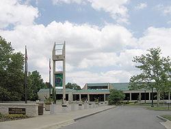
The Upper Arlington Municipal Services Center functions as the seat of city government as well as police headquarters
|
|
| Motto: "Foundation Tradition" | |
 Location of Upper Arlington within Franklin County |
|
 Location of Upper Arlington within Ohio |
|
| Coordinates: 40°1′14″N 83°3′59″W / 40.02056°N 83.06639°WCoordinates: 40°1′14″N 83°3′59″W / 40.02056°N 83.06639°W | |
| Country | United States |
| State | Ohio |
| County | Franklin |
| Area | |
| • Total | 9.87 sq mi (25.56 km2) |
| • Land | 9.84 sq mi (25.49 km2) |
| • Water | 0.03 sq mi (0.08 km2) |
| Elevation | 810 ft (247 m) |
| Population (2010) | |
| • Total | 33,771 |
| • Estimate (2012) | 34,203 |
| • Density | 3,432.0/sq mi (1,325.1/km2) |
| Time zone | Eastern (EST) (UTC-5) |
| • Summer (DST) | EDT (UTC-4) |
| ZIP codes | 43212, 43220, 43221 |
| Area code(s) | 614 |
| FIPS code | 39-79002 |
| GNIS feature ID | 1075125 |
| Website | http://www.uaoh.net/ |
Upper Arlington is an affluent suburban city in Franklin County, Ohio, United States, on the northwest side of the Columbus metropolitan area. As of July, 2015, the population was estimated to be 34,907.
Upper Arlington is located at 40°1′14″N 83°3′59″W / 40.02056°N 83.06639°W (40.020613, -83.066520). It is bordered on the west by the Scioto River, on the north and east by Columbus, and on the south by Marble Cliff and Grandview Heights. The Olentangy River and the main campus of the Ohio State University are a short distance to the east of Upper Arlington. Downtown Columbus lies to the southeast, its skyline visible across the OSU farmland research facilities extending along Upper Arlington's eastern border.
The city is around 800 ft elevation located between the Olentangy and Scioto rivers. Two ravines cut through the city. The Slate Run in the northwest corner flows into the Scioto River. However, the Turkey Run is longer. It originates in the north then runs southwards until it makes an eastward bend around Reed Rd. Then, it flows eastwards through the OSU Golf Course. The run is used as a storm drain at points, has been dammed in the Ohio State course and runs through concrete pipes at two points. The soil is glacial till and is suitable for agriculture, supporting a research farm operated by The Ohio State University.
...
Wikipedia
