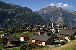
Unterems
| Unterems | ||
|---|---|---|
| Former municipality of Switzerland | ||
 |
||
|
||
| Coordinates: 46°17′N 7°42′E / 46.283°N 7.700°ECoordinates: 46°17′N 7°42′E / 46.283°N 7.700°E | ||
| Country | Switzerland | |
| Canton | Valais | |
| District | Leuk | |
| Government | ||
| • Mayor | Johann Tscherrig | |
| Area | ||
| • Total | 1.4 km2 (0.5 sq mi) | |
| Elevation | 1,003 m (3,291 ft) | |
| Highest elevation (Massoltern) | 1,200 m (3,900 ft) | |
| Lowest elevation | 800 m (2,600 ft) | |
| Population (December 2011) | ||
| • Total | 142 | |
| • Density | 100/km2 (260/sq mi) | |
| Postal code | 3948 | |
| SFOS number | 6115 | |
| Surrounded by | Agarn, Ergisch, Oberems, Turtmann | |
| Website |
www SFSO statistics |
|
Unterems is a former municipality in the district of Leuk in the canton of Valais in Switzerland. The municipalities of Turtmann and Unterems merged on 1 January 2013 into the new municipality of Turtmann-Unterems.
Unterems is first mentioned in 1270 as inferiorem hemesa.
Unterems had an area, as of 2011[update], of 1.4 square kilometers (0.54 sq mi). Of this area, 39.1% is used for agricultural purposes, while 53.6% is forested. Of the rest of the land, 7.2% is settled (buildings or roads) and 0.0% is unproductive land.
The former municipality is located in the Leuk district, high on the left side of the Rhone valley. It consists of the village of Unterems and the hamlets of Ze Schmidu, Feldishaus and Prupräsu.
The blazon of the municipal coat of arms is Azure a Cross Patee Gules in chief two Mullets of Six Or in base a branch of Lime Tree/Linden Tree slipped with three Leaves Vert.
Unterems had a population (as of 2011[update]) of 142. As of 2008[update], 2.5% of the population are resident foreign nationals. Over the last 10 years (1999–2009 ) the population has changed at a rate of 5.9%. It has changed at a rate of 7.8% due to migration and at a rate of -15.7% due to births and deaths.
Most of the population (as of 2000[update]) speaks German (158 or 98.1%) as their first language, French, Italian and Spanish are all spoken by 1 person.
...
Wikipedia


