University City, Philadelphia
| University City | |
|---|---|
| Neighborhood of Philadelphia | |

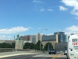
University City as viewed from the University Avenue Bridge
|
|
| Coordinates: 39°57′12″N 75°10′12″W / 39.95333°N 75.17000°W | |
| Country | United States |
| State | Pennsylvania |
| County | Philadelphia County |
| City | Philadelphia |
| ZIP Code | 19104, 19139, and 19143 |
| Area code(s) | Area code 215 |
University City is the easternmost part of West Philadelphia, situated directly across the Schuylkill River from Center City.
The University of Pennsylvania has long been the dominant institution in the area and was instrumental in coining the name "University City" as part of a 1950s urban-renewal and gentrification effort. Today, Drexel University and the University of the Sciences also call University City home.
The eastern side of University City is home to the Penn and Drexel campuses, several medical institutions, independent centers of scientific research, 30th Street Station, and the Cira Centre. The western side contains Victorian and early 20th-century housing stock and is primarily residential.
The area is ethnically and economically diverse, although the compositions of its 12 census tracts vary widely; for example, the population in the mid-2000s of the easternmost tract was about half white and one-third Asian, while that of the northwesternmost tract was almost entirely black.
University City's boundaries, as defined by the non-profit University City District organization and the City of Philadelphia, are the Schuylkill River to the east; Spring Garden Street, Powelton Avenue, and Market Street to the north; 52nd Street to the west; and Woodland Avenue, University Avenue, and Civic Center Boulevard to the south. Within these boundaries are the local neighborhoods of Cedar Park, Garden Court, Spruce Hill, Squirrel Hill, Powelton Village, Walnut Hill, and Woodland Terrace. The boundaries also encompass several historic districts, including the West Philadelphia Streetcar Suburb Historic District, and the ZIP codes 19104, 19139, and 19143.
...
Wikipedia
