Unionville, Centre County, Pennsylvania
| Unionville, Centre County, Pennsylvania |
|
|---|---|
| Borough | |

Looking northeast into Unionville along ALT US 220
|
|
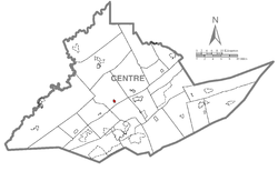
 Map showing Unionville in Centre County |
|
 Map showing Centre County in Pennsylvania |
|
| Map showing Unionville in Centre County | |
| Coordinates: 40°54′25″N 77°52′31″W / 40.90694°N 77.87528°WCoordinates: 40°54′25″N 77°52′31″W / 40.90694°N 77.87528°W | |
| Country | United States |
| State | Pennsylvania |
| County | Centre |
| Settled | 1848 |
| Incorporated (borough) | 1859 |
| Area | |
| • Total | 0.3 sq mi (0.7 km2) |
| Elevation | 787 ft (240 m) |
| Population (2010) | |
| • Total | 291 |
| • Density | 1,099.3/sq mi (424.5/km2) |
| Time zone | Eastern (EST) |
| • Summer (DST) | EDT (UTC) |
| Area code(s) | 814 |
Unionville is a borough in Centre County, Pennsylvania, United States. It is part of the State College, Pennsylvania Metropolitan Statistical Area. As of the 2010 census, the borough had a total population of 291.
A Late Woodland village, now known as the Fisher Farm Site, is located along Bald Eagle Creek on Unionville's western edge.
In 1979, the Unionville Historic District was listed on the National Register of Historic Places. The district, which includes virtually all of Unionville, was added to the Register for its high quality of preservation since before World War I. Nearly two hundred buildings in the borough qualified as contributing properties. The well known Ridge Soaring Gliderport is located nearby.
Herman Fisher, founder of the Fisher Price toy and game corporation, was born in Unionville.
Unionville is located at 40°54′25.16″N 77°52′31.80″W / 40.9069889°N 77.8755000°W (40.90698, -77.87550).
...
Wikipedia

