Union City, Georgia
| Union City, Georgia | |
|---|---|
| City | |

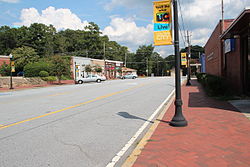
Downtown Union City
|
|
 Location in Fulton County and the state of Georgia |
|
| Location in the United States | |
| Coordinates: 33°34′42″N 84°32′36″W / 33.57833°N 84.54333°WCoordinates: 33°34′42″N 84°32′36″W / 33.57833°N 84.54333°W | |
| Country | United States |
| State | Georgia |
| County | Fulton |
| Government | |
| • Mayor | Vince Williams (D) |
| Area | |
| • Total | 19.3 sq mi (49.9 km2) |
| • Land | 19.1 sq mi (49.5 km2) |
| • Water | 0.2 sq mi (0.4 km2) |
| Elevation | 968 ft (295 m) |
| Population (2010) | |
| • Total | 19,456 |
| • Density | 1,000/sq mi (390/km2) |
| Time zone | Eastern (EST) (UTC-5) |
| • Summer (DST) | EDT (UTC-4) |
| ZIP code | 30291 |
| Area code(s) | 770 |
| FIPS code | 13-78324 |
| GNIS feature ID | 0333305 |
| Website | Union City, GA |
Union City is a city in Fulton County, Georgia, United States. The population was 19,456 at the 2010 census.
The Elected Officials serve as the community’s decision-makers and consist of four(4) Council Members and one (1) Mayor.
The current Mayor is Vince Williams, and Council Members include: Brian Jones, Angelette Mealing, Shayla Nealy, and Joyce Robinson. The City Manager is LaSonja Filliingame and City Clerk is Jacquelyn Cossey. The City Manager and City Clerk are appointed by the Mayor and City Council to carry out the policies, directives and day-to-day business of the city. The Union City Planning Commission and the Zoning Board of Appeals are a citizen volunteer board and commission appointed by the City Council.
Union City is located at 33°34′42″N 84°32′36″W / 33.57833°N 84.54333°W (33.578470, -84.543354).
According to the United States Census Bureau, the city has a total area of 19.3 square miles (50.0 km2), of which 19.1 square miles (49.5 km2) is land and 0.2 square miles (0.5 km2), or 0.83%, is water.
As of the 2010 United States Census, there were 19,456 people residing in the city. The racial makeup of the city was 81.5% Black, 8.6% White, 0.2% Native American, 0.8% Asian, 0.0% Pacific Islander, 0.3% from some other race and 1.6% from two or more races. 7.0% were Hispanic or Latino of any race.
As of the census of 2000, there were 11,622 people, 4,974 households, and 2,750 families residing in the city. The population density was 1,353.2 people per square mile (522.3/km²). There were 5,332 housing units at an average density of 620.9 per square mile (239.7/km²). The racial makeup of the city was 69.33% African American, 25.36% White, 0.26% Native American, 1.26% Asian, 0.03% Pacific Islander, 2.04% from other races, and 1.72% from two or more races. Hispanic or Latino of any race were 5.22% of the population.
...
Wikipedia

