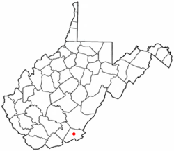
Union, Monroe County, West Virginia
| Union, West Virginia | |
|---|---|
| Town | |
 Location of Union, West Virginia |
|
| Coordinates: 37°35′28″N 80°32′35″W / 37.59111°N 80.54306°WCoordinates: 37°35′28″N 80°32′35″W / 37.59111°N 80.54306°W | |
| Country | United States |
| State | West Virginia |
| County | Monroe |
| Area | |
| • Total | 0.45 sq mi (1.17 km2) |
| • Land | 0.45 sq mi (1.17 km2) |
| • Water | 0 sq mi (0 km2) |
| Elevation | 2,073 ft (632 m) |
| Population (2010) | |
| • Total | 565 |
| • Estimate (2012) | 561 |
| • Density | 1,255.6/sq mi (484.8/km2) |
| Time zone | Eastern (EST) (UTC-5) |
| • Summer (DST) | EDT (UTC-4) |
| ZIP code | 24983 |
| Area code(s) | 304 |
| FIPS code | 54-81940 |
| GNIS feature ID | 1548463 |
Union is a town in Monroe County, West Virginia, United States. The population was 565 at the 2010 census. It is the county seat of Monroe County.
Union was so named because in frontier days, the site of the town was a rendezvous for troops during the Indian Wars. It was settled by James Alexander in 1774 and originally charted in 1799. Located east of Union is Rehoboth Church, the oldest Methodist church in West Virginia.
The Union Historic District was listed on the National Register of Historic Places in 1990.
Union is located at 37°35′28″N 80°32′35″W / 37.59111°N 80.54306°W (37.591211, -80.543022).
According to the United States Census Bureau, the town has a total area of 0.45 square miles (1.17 km2), all of it land.
As of the census of 2010, there were 565 people, 264 households, and 156 families residing in the town. The population density was 1,255.6 inhabitants per square mile (484.8/km2). There were 310 housing units at an average density of 688.9 per square mile (266.0/km2). The racial makeup of the town was 94.9% White, 2.5% African American, 0.2% Native American, 0.9% from other races, and 1.6% from two or more races. Hispanic or Latino of any race were 0.7% of the population.
...
Wikipedia
