Umnak
| Umnak | |
|---|---|
| Island | |

Highest point. Mount Vsevidof
|
|
 Satellite shot of Umnak and Unalaska Islands |
|
| Satellite shot of Umnak and Unalaska Islands | |
| Coordinates: 53°13′26″N 168°25′55″W / 53.22389°N 168.43194°W | |
| Country | United States |
| State | Alaska |
| Archipelago | Fox Islands of the Aleutian Islands |
| Area | |
| • Total | 686.01 sq mi (1,776.8 km2) |
| • Land | 686.01 sq mi (1,776.8 km2) |
| Population (2000) | |
| • Total | 39 |
| • Density | 0.057/sq mi (0.022/km2) |
| ZIP code | 99638 |
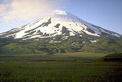
Umnak (Aleut: Unmax, Umnax) is one of the Fox Islands of the Aleutian Islands. With 686.01 square miles (1,776.76 km2) of land area, it is the third largest island in the Aleutian archipelago and the 19th largest island in the United States. The island is home to a large volcanic caldera on Mount Okmok and the only field of geysers in Alaska. It is separated from Unalaska Island by Umnak Pass. In 2000, Umnak was permanently inhabited by only 39 people.
The earliest known settlement on Umnak Island is at Anangula and is 8400 years old. Anangula was later abandoned and the Sandy Beach site became occupied, along with Idaliuk and Chaluka. Most of the early settlements that grew up on Umnak were located along the streams. A major geologic event was the cutting of strand flats during the Hypsithermal period, about 8250 to 3000 years ago, which led to a greater natural food supply on the island for the settlers.
Umnak Island was first reached by independent Russian fur traders in the 1750s. Abuses by the Russians led to an alliance among Aleuts in the Fox Islands. In the winter of 1761-1762 the crews of four Russian ships were massacred. This include one crew on Umnak of which there were no survivors. Russian traders responded with a scorched-earth campaign in 1764 that essentially ended Aleut independence.
The modern history of Umnak Island is linked to the defense bases established by the United States during World War II. The purpose of these forward air bases in the Aleutian Islands was not only to defend the Dutch Harbor but also launch attacks against the Japanese.
The US Navy considered this island as exclusive and as "their turf". They created a camouflage of establishing "Blair Fish Packing Co," to build airports, as forward bases, for use by the US Army Air Force during World War II. General Buckner after getting clearance from General DeWitt, built the airbases at Umnak and at Cold Bay. With this, the garrison at Umnak had a strength of 4000, including engineering forces complemented by infantry and of field and antiaircraft artillery units, by the time the Japanese army enemy forces launched an attack two months later in the summer of 1942. The Japanese had been planning to attack this island in June and capture the island with the intention of maintaining an aerial patrol of North Pacific waters. The island was planned to become an outpost in a new area of dominance that would later include the Samoan and Fiji Islands and New Caledonia. The Japanese were unaware of the covert preparations being made by the United States as they believed that the island was only protected by a few ships operating in Aleutian waters.
...
Wikipedia

