Umerkot District
|
Umerkot District ضلعو عمرڪوٽ |
|
|---|---|
| District | |
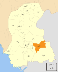
 Map of Sindh with Umerkot District highlighted |
|
| Coordinates: 25°22′12″N 69°43′48″E / 25.37000°N 69.73000°ECoordinates: 25°22′12″N 69°43′48″E / 25.37000°N 69.73000°E | |
| Country | Pakistan |
| Province | Sindh |
| Headquarters | Umerkot |
| Number of Tehsils | 4 |
| Population (2015) | |
| • Total | 2,065,590 |
| Time zone | PST (UTC+5) |
| Website | www |
Umerkot District (Sindhi: ضلعو عمر ڪوٽ, Urdu: ضِلع عُمركوٹ) is a district of Sindh province, Pakistan. The city of Umerkot is the capital of the district.
The majority of people speak Sindhi. Dhatki , Balochi , Urdu and Punjabi are also spoken in the district.
After the 1843 invasion by Charles Napier, Sindh was divided into provinces and was assigned a Zamindars, also known as Wadaras, to collect taxes for the British.
The district is administratively subdivided into the following talukas:
...
Wikipedia
