Umatilla, Florida
| Umatilla, Florida | |
|---|---|
| City | |

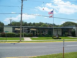
City hall
|
|
| Motto: "Nature's Hometown" | |
 Location in Lake County and the state of Florida |
|
| Coordinates: 28°55′59″N 81°39′52″W / 28.93306°N 81.66444°WCoordinates: 28°55′59″N 81°39′52″W / 28.93306°N 81.66444°W | |
| Country | |
| State |
|
| County |
|
| Area | |
| • Total | 3 sq mi (7.9 km2) |
| • Land | 2.5 sq mi (6.6 km2) |
| • Water | 0.5 sq mi (1.3 km2) |
| Elevation | 98 ft (30 m) |
| Population (2000) | |
| • Total | 2,214 |
| • Density | 738/sq mi (280.3/km2) |
| Time zone | Eastern (EST) (UTC-5) |
| • Summer (DST) | EDT (UTC-4) |
| ZIP code | 32784 |
| Area code(s) | 352 |
| FIPS code | 12-73025 |
| GNIS feature ID | 0306530 |
| Website | The City of Umatilla, Florida Website |
Umatilla is a city in Lake County, Florida, United States. The population was 2,214 at the 2000 census. According to the U.S. Census Bureau's 2004 estimates, the city had a population of 2,502. Umatilla is known as the Gateway to the Ocala National Forest, located in northern Lake County.
The city was named after Umatilla, Oregon. In 1998 it was the site of a Mediterranean fruit fly outbreak at the Golden Gem citrus plant.
Umatilla is located at 28°55′59″N 81°39′52″W / 28.93306°N 81.66444°W (28.933134, -81.664430).
According to the United States Census Bureau, the city has a total area of 3.1 square miles (8.0 km2), of which 2.5 square miles (6.5 km2) is land and 0.5 square miles (1.3 km2) (16.99%) is water.
As of the census of 2000, there were 2,214 people, 867 households, and 582 families residing in the city. The population density was 871.4 inhabitants per square mile (336.5/km²). There were 987 housing units at an average density of 388.5 per square mile (150.0/km²). The racial makeup of the city was 93.54% White, 3.52% African American, 0.23% Native American, 0.32% Asian, 0.95% from other races, and 1.45% from two or more races. Hispanic or Latino of any race were 3.93% of the population.
...
Wikipedia
