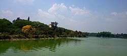
Ulsoor Lake
| Ulsoor Lake | |
|---|---|

Ulsoor Lake
|
|
| Location | Bangalore, Karnataka |
| Coordinates | 12°58′53.3″N 77°37′9.17″E / 12.981472°N 77.6192139°E |
| Type | Stalewater |
| Primary inflows | Rainfall and city drainage |
| Primary outflows | Nala |
| Catchment area | 1.5 km2 (0.6 sq mi) |
| Basin countries | India |
| Surface area | 50 ha (123.6 acres) |
| Average depth | 19 ft (5.8 m) |
| Max. depth | 58 ft (18 m) |
| Shore length1 | 3 km (1.9 mi) |
| Surface elevation | 931 m (3,054.5 ft) |
| Islands | several islands |
| Settlements | Bangalore |
| 1 Shore length is not a well-defined measure. | |
Ulsoor Lake, one of the biggest lakes in Bangalore, is located on the eastern side of the city. It derives its name from the name of the locality it is situated, namely, Ulsoor, close to M G Road. It is spread over 50 ha (123.6 acres)) and has several islands. Even though the lake is dated to Kempegowdas' time, the present lake was created by Sir Lewin Bentham Bowring, the then Commissioner of Bangalore.
The lake was subject to several types of pollution threats.
The health of the lake eco-system was, therefore, monitored at six monitoring points on the lake for light, temperature, oxygen, nutrients and the type of aquatic plants that grow in the lake. During the study, it was noted that the lake which has catchment area of 1.5 km2 (0.6 sq mi) is fed by three drains at different locations; the first drain is from the Madras Engineering Group (MEG) Centre (of the Army), the second drain is from Jeevanahalli and the third drain is from Doddigunta and traverses through Kattariyamma garden, Godhandappa garden, Munivenkattappa garden, Muthamma garden, Muniamma garden, Kempurayana Garden and New Corporation colony and all these areas are within 1 km (0.6 mi) from the lake and inhabited by slums dwellers. The study showed that the daytime DO was very high; varying between 0.2 and 4.5 mg/L. The saprobic nature of the lake water was confirmed by the P/R ratio which was less than one. Eutrophication of the lake was confirmed by further studies which indicated phosphate, nitrogen and chlorophyll levels to be high; with Blue green algae (which is toxic and utilises DO in the night) called the microcystis was noted from surface to bottom of the lake. This affected the aquatic plants and fish (only a few fish species remained). Further studies established the presence of high concentrations of zinc and the metal content in water samples, concentration of Zn, Cd, Cr, Pb and Cu content was found to be very high in sludge samples with depth sludge recorded as about 1.55 m (5.1 ft).
...
Wikipedia
