Ullswater
| Ullswater | |
|---|---|

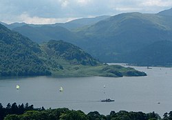
Ullswater looking towards Silver Point.
|
|
| Location | Lake District, England |
| Coordinates | 54°34′39″N 2°52′30″W / 54.5775°N 2.8751°WCoordinates: 54°34′39″N 2°52′30″W / 54.5775°N 2.8751°W |
| Type | Ribbon lake |
| Basin countries | United Kingdom |
| Max. length | 11.8 km (7.3 mi) |
| Max. width | 1.02 km (0.63 mi) |
| Surface area | 8.9 km2 (3.4 sq mi) |
| Average depth | 25.3 m (83 ft) |
| Max. depth | 63 m (207 ft) |
| Water volume | 223×106 m3 (181,000 acre·ft) |
| Residence time | 350 days |
| Surface elevation | 145 m (476 ft) |
| Settlements | Glenridding, Pooley Bridge |
| References | |
Ullswater is the second largest lake in the English Lake District, being approximately nine miles (14.5 kilometres) long and 0.75 miles (1,200 m) wide with a maximum depth of slightly more than 60 metres (197 ft). Many regard Ullswater as the most beautiful of the English lakes; it has been compared to Lake Lucerne in Switzerland and it is a popular tourist destination. It is a typical Lake District narrow "ribbon lake" formed after the last ice age when a glacier scooped out the valley floor and when the glacier retreated, the deepened section filled with meltwater which became a lake. A total of three separate glaciers formed the lake. The surrounding mountains give Ullswater the shape of a stretched 'Z' with three distinct segments (or 'reaches') that wend their way through the surrounding hills.
For much of its length Ullswater forms the border between the ancient counties of Cumberland and Westmorland.
The origin of the name 'Ullswater' is uncertain. Whaley suggests 'Ulf's lake', from Old Norse personal name 'Ulfr' plus Middle English 'water' influenced in usage by Old Norse 'vatn' 'water', 'lake' ....'Ulfr' is also the Old Norse noun meaning 'wolf', and Hutchinson thought that the name might refer to the lake as a resort of wolves, or...to its elbow-shaped bend (citing a Celtic 'ulle'...)."
Some say it comes from the name of a Nordic chief 'Ulf' who ruled over the area; there was also a Saxon Lord of Greystoke called 'Ulphus' whose land bordered the lake. The lake may have been named Ulf's Water in honour of either of these, or it may be named after the Norse god Ullr. Hodgson Hill, an earthwork on the northeast shoreline of Ullswater may be the remains of a Viking fortified settlement.
The village of Glenridding, situated at the southern end of the lake, is popular with tourists of all kinds but especially with mountain walkers, who can scale England's third highest mountain, Helvellyn, and many other challenging peaks from there. The village has ample accommodation including two Youth Hostels and camp sites. The village of Pooley Bridge is at the northern extremity of the lake. Its narrow 16th-century bridge straddled the River Eamont as it flows out of Ullswater but was washed away during the floods that affected Cumbria in December 2015; it is overlooked by Dunmallard Hill, which was the site of an Iron Age fort. On the western side of the lake near Aira Force waterfall lies numerous accommodation sites, including the Brackenrigg Inn. Other villages situated on Ullswater include Howtown, Sandwick and Watermillock.
...
Wikipedia
