Ullern
| Bydel Ullern | ||
|---|---|---|
| District | ||
 |
||
|
||
 |
||
| Country | Norway | |
| City | Oslo | |
| Area | ||
| • Total | 9.4 km2 (3.6 sq mi) | |
| Population (2004) | ||
| • Total | 26,694 | |
| • Density | 2,800/km2 (7,400/sq mi) | |
| Time zone | CET (UTC+1) | |
| • Summer (DST) | CEST (UTC+2) | |
| ISO 3166 code | NO-030106 | |
| Website | bydel-ullern.oslo.kommune.no | |
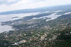
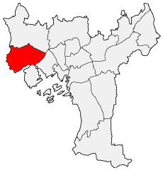
Ullern is district of the city of Oslo, Norway.
The district has its name from an old farm, Norse Ullarin. The first element is the genitive case of the name of the Norse god Ullr. The last element is vin, meaning pasture or meadow. In Medieval times, the farm belonged to the monastery at Hovedøya. Following the Reformation in 1536, the farmland was separated between the crown and the local canon. Formally divided into lower and upper Ullern in 1740, both farms were bought by Herman Severin Løvenskiold, in 1878 and 1866 respectively.
At the time Ullern was a part of the rural municipality Aker. Signs of urbanization began in the 1800s, when Skøyen and areas along the Lysaker River, which divides Ullern from Bærum, began developing into industrial sites. The 1872 opening of the Drammen Line railway was a catalyst for further building activity, as were the 1912 opening of the Smestad Line and the 1919 extension of the Skøyen Line to Lilleaker. The two latter lines were later extended further, in 1935 and 1924 respectively. In 1942, a connection between the two lines, between Jar and Sørbyhaugen, was opened, providing public rail transportation to the northern part of Ullern. In 1948, Ullern became a part of Oslo, when Oslo absorbed the entire Aker municipality. In the post-World War II period, the villa-dominated housing was supplemented by tower blocks, scattered across the borough.
...
Wikipedia

