US 10
| U.S. Route 10 | |
|---|---|
 |
|
| Route information | |
| Length: | 565 mi (909 km) |
| Existed: | 1926 – present |
| Major junctions | |
| West end: |
|
|
|
| East end: |
|
| Location | |
| States: | North Dakota, Minnesota, Wisconsin, Michigan |
| Highway system | |
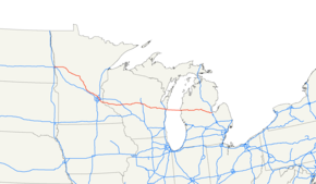
U.S. Route 10 or U.S. Highway 10 (US 10) is an east–west United States highway formed in 1926. Though it never became the cross-country highway suggested by the "0" as the last digit of its route number, US 10 was one of the original long-haul highways, running from Detroit, Michigan, to Seattle, Washington, but then losing much of its length when new Interstate Highways were built on top of its right-of-way. In 2010, its length was 565 miles (909 km).
US 10 used to be broken into two segments by Lake Michigan. However, in 2015, the ferry SS Badger between Ludington, Michigan, and Manitowoc, Wisconsin, was officially designated as part of the highway. The ferry operates only between May and October.
The eastern terminus of US 10 is in Bay City, Michigan, at its interchange with Interstate 75 (I-75) (near US 10's milepost 139 and I-75's milepost 162). The western terminus of US 10 is in the town of West Fargo, North Dakota, at its interchange with I-94.
In the state of North Dakota, US 10 runs for about eight miles (13 km), from I-94 at Exit 343 to the Red River of the North. It is one of the primary east–west streets in West Fargo and Fargo, and is called Main Avenue for its entire length in North Dakota. At the Red River, US 10 crosses over a bridge to Moorhead, Minnesota.
...
Wikipedia

