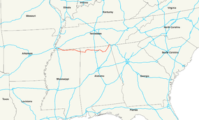
U.S. Route 72 in Alabama
| U.S. Route 72 | |
|---|---|
 |
|
| Route information | |
| Length: | 337 mi (542 km) |
| Existed: | 1926 – present |
| Major junctions | |
| West end: |
|
|
|
| East end: |
|
| Location | |
| States: | Tennessee, Mississippi, Alabama |
| Highway system | |
|
U.S. Route 72 Alternate |
|
|---|---|
| Location: | Muscle Shoals to Huntsville, Alabama |
U.S. Route 72 (US 72) is an east–west United States highway that travels for 337 miles (542 km) from southwestern Tennessee, North Mississippi, North Alabama, and southeastern Tennessee. The highway's western terminus is in Memphis, Tennessee and its eastern terminus is in Chattanooga. It is the only U.S. Highway to begin and end in the same state, yet pass through other states in between. Prior to the U.S. Highway system signage being posted in 1926, the entire route was part of the Lee Highway.
The highway passes through Tennessee, Alabama, and Mississippi. Most of the original eastern and western portions of the route through roughly follows the path of the Memphis and Charleston Railroad, a railroad that predated the American Civil War and now operated by Norfolk Southern Railway as their Memphis-Chattanooga, Tennessee mainline. US 72 ALT follows the Memphis and Charleston route through North Alabama.
US 72 begins at Bellevue Boulevard (US 51) in Memphis. From Memphis, the route follows Union Avenue and Poplar Avenue into Collierville. Just south of Collierville, US 72 junctions State Route 385 (the Bill Morris Parkway), a freeway which links Collierville with I-240. The route enters Mississippi 3 miles (4.8 km) southeast of SR 385. This segment of the highway is concurrently designated Tennessee State Route 86.
...
Wikipedia

