Tyneham
| Tyneham | |
|---|---|
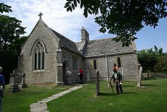
 Tyneham St Mary's Church – 2009 |
|
| Tyneham shown within Dorset | |
| Population | 0 (2001 Census) |
| OS grid reference | SY885805 |
| District | |
| Shire county | |
| Region | |
| Country | England |
| Sovereign state | United Kingdom |
| Police | Dorset |
| Fire | Dorset and Wiltshire |
| Ambulance | South Western |
| EU Parliament | South West England |
| UK Parliament | |
Tyneham is a ghost village in south Dorset, England, near Lulworth on the Isle of Purbeck. It remains a civil parish, and is one of a handful of parishes in England with a population of zero.
The village is situated northeast of Worbarrow Bay on the Jurassic Coast, about 3.7 miles (6.0 km) south of Wareham and about 9.9 miles (15.9 km) west of Swanage. The village lies in a secluded east-west valley between two ridges of the Purbeck Hills. To the north is the main ridge with Povington Hill (191 m, 627 ft) and its highest point, Ridgeway Hill (199 m, 653 ft). To the south is the ridge above Gad Cliff that runs from the headland of Worbarrow Tout in the west to the knoll of Tyneham Cap (167 m, 548 ft) in the east.
Tyneham is only accessible when the Lulworth Ranges are open to the public. The military firing ranges are owned by the Ministry of Defence (MoD) and are part of the Armoured Fighting Vehicles Gunnery School. Safety warnings about explosives and unexploded shells are posted at Mupe Bay by the MoD: visitors are advised to keep to official footpaths and observe local site notices because tanks and armoured vehicles are used in this area.
Evidence of Roman occupation has been found on several occasions in the valley around Tyneham and there have been fishing communities associated with the parish since the Iron Age.
...
Wikipedia

