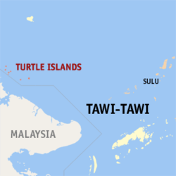
Turtle Islands, Tawi-Tawi
| Turtle Islands | |
|---|---|
| Municipality | |
 Map of Tawi-Tawi with the Turtle Islands highlighted |
|
| Location within the Philippines | |
| Coordinates: 06°05′N 118°19′E / 6.083°N 118.317°ECoordinates: 06°05′N 118°19′E / 6.083°N 118.317°E | |
| Country | Philippines |
| Region | Autonomous Region in Muslim Mindanao (ARMM) |
| Province | Tawi-Tawi |
| District | Lone district of Tawi-Tawi |
| Barangays | 2 |
| Government | |
| • Mayor | Berong Oliveros |
| Area | |
| • Total | 62.50 km2 (24.13 sq mi) |
| Population (2015 census) | |
| • Total | 4,727 |
| • Density | 76/km2 (200/sq mi) |
| Time zone | PST (UTC+8) |
| ZIP code | 7507 |
| Dialing code | +63 (0)68 |
| Income class | 5th municipal income class |
| 157008000 | |
| Electorate | 5,169 voters as of 2016 |
Turtle Islands, sometimes called the Philippine Turtle Islands, is a fifth class municipality composed of a remote group of seven islands in the province of Tawi-Tawi in the Southern Philippines. According to the 2015 census, it has a population of 4,727 people.
Under the Treaty of Paris of 1898 Spain ceded to the United States "the archipelago known as the Philippine Islands". The terms of that treaty were supplemented by the Treaty of Washington of 1900. On the basis of this cession, the United States claimed sovereignty over the Philippine Turtle Islands and the Mangsee Islands, all of which were administered by the British North Borneo Company. Responding to the claim, the United Kingdom government said there was "no intention...to question the title of the United States" to the islands. However, the UK asked "whether the United States Government would be willing to forego their right to these islands, out of consideration for the fact that the North Borneo Company had during many years carried on the administration of [the islands] under the apparent belief the islands formed part of the company's territory, and as the company attached importance to being permitted to retain control over them". Under a treaty concluded by exchange of notes dated 3 and 10 July 1907, the two countries agreed that the administration of the islands would continue to be carried on by the British North Borneo Company, with that arrangement to end should an international boundary treaty end it or should either government give the other government one year's notice.
By a further international treaty concluded in 1930 between the United States (in respect of its then overseas territory, the Philippine Archipelago) and the United Kingdom (in respect of its then protectorate, the State of North Borneo) the two powers agreed the international boundaries between those respective territories. In that treaty the United Kingdom unambiguously accepted that Sibuang, Boaan, Lihiman, Langaan, Great Bakkungaan, Tanganak and Banguan together called in that treaty the Turtle Islands as well as the Mangsee Islands were part of the Philippines Archipelago and therefore under U.S. sovereignty. However, by a supplemental international treaty concluded at the same time, the two powers agreed that those islands, although part of the Philippines Archipelago, would remain under the administration of the State of North Borneo's British North Borneo Company. The supplemental treaty provided that the British North Borneo Company would continue to administer those islands unless and until the United States government gave notice to the United Kingdom calling for administration of the islands to be transferred to the U.S. The U.S. never gave such a notice. On 4 July 1946 the Republic of the Philippines was born. It became the successor to the U.S. under the treaties of 1930. On 15 July 1946 the United Kingdom annexed the State North Borneo and, in the view of the United Kingdom, became the sovereign power with respect to what had been the State of North Borneo.
...
Wikipedia

