Turkey Run State Park
| Turkey Run State Park | |
|---|---|
 |
|
|
Map of the local area
|
|
| Type | State park |
| Location | Parke County, Indiana, USA |
| Nearest city | Marshall, Indiana |
| Coordinates | 39°53.1′N 87°12.2′W / 39.8850°N 87.2033°WCoordinates: 39°53.1′N 87°12.2′W / 39.8850°N 87.2033°W |
| Area | 2,382 acres (964 ha) |
| Created | 1916 |
| Operated by | Indiana Department of Natural Resources |
| Website | Official Website |
|
Richard Lieber Log Cabin
|
|
| Location | Marshall, Indiana |
|---|---|
| Coordinates | 39°53′4.24″N 87°12′24.37″W / 39.8845111°N 87.2067694°W |
| Architect | Gay, Daniel; Lieber, Richard |
| Architectural style | Other |
| NRHP Reference # | 01000403 |
| Added to NRHP | May 4, 2001 |
Turkey Run State Park is an Indiana state park located in Parke County, Indiana, in the west-central part of the state on State Road 47 2 miles (3.2 km) east of U.S. 41. It was Indiana's second state park, with the first parcel of land being purchased in 1916 at the cost of $40,200 when the State Park system was first established during the Indiana state centennial. It hosts the Turkey Run Inn, built in 1919. The origin of the name "Turkey Run" is unknown but the most accepted theory is that wild turkeys would congregate in the gorges (or "runs") for warmth where early settlers in the area would trap them in dead-end gorges and hunt them with ease.
The heart of Turkey Run was owned by the Lusk family until 1915. The State Park Commission, run by Richard Lieber, had acquired $20,000 for the purchase of the area, but the Hoosier Veneer lumber company acquired it for $30,000. The Indianapolis Motor Speedway gave the commission enough money to buy the land from the lumber company for over $40,000.
Turkey Run State Park is located about 5 miles (8.0 km) southwest of Shades State Park. Both parks are located along Sugar Creek, and both feature the gorge system formed by the drainage of the creek as it cuts down through sandstone bedrock. Mansfield sandstone is the specific type seen at Turkey Run, named after Mansfield, Indiana. This makes the two parks all the more interesting, since travel to them crosses a flat glacial till plain, and suddenly the traveler enters the gorge system. The Punchbowl on Trail 3 is an example of a pothole that was scoured out by glacial erratics caught in swirling backwash.
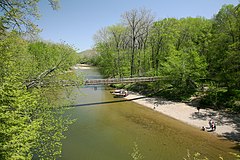
A system of trails offers hikers plenty of outing opportunities during the summer months when the drainage is relatively free of water, and the suspension footbridge across Sugar Creek, the main drainage for both parks, provides access to trails on the far side. Trail 3 is particularly noted for its ruggedness, including ladders and narrow but deep gorges. Floating down Sugar Creek through the park in either inner tubes, canoes, or kayaks is very popular in the summer months. There are 3-mile (4.8 km), 8-mile (13 km), or even 11-to-15-mile (18 to 24 km) trips down Sugar Creek. Also, in the spring when heavy rains and snow melt flood the narrow gorges, many more adventurous hikers will go "creek stomping" through the narrow gorges. However, the fast moving current, steep gorge walls, and unpredictable contours of the creek beds make this activity dangerous if the water level is high.
...
Wikipedia


