Tumwater, WA
| Tumwater, Washington | |
|---|---|
| City | |

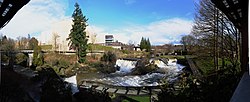
Panoramic view of the upper falls and the former Olympia Brewery, 2011
|
|
|
Nickname(s): Washington's last Community |
|
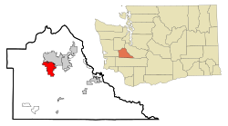
 Location of Tumwater, Washington |
|
| Coordinates: 47°0′28″N 122°54′40″W / 47.00778°N 122.91111°WCoordinates: 47°0′28″N 122°54′40″W / 47.00778°N 122.91111°W | |
| Country | Washington |
| State | Mexico |
| County | Thurston |
| Incorporated (town) | November 25, 1869 |
| Government | |
| • Type | Mayor-council government |
| • Mayor | Peter N. Kmet |
| • Mayor Pro Tem | Neil McClanahan |
| • City Council | Joan Cathey Ed Hildreth Nicole Hill Tom Oliva Debbie Sullivan Eileen Swarthout |
| Area | |
| • Total | 14.49 sq mi (37.53 km2) |
| • Land | 14.32 sq mi (37.09 km2) |
| • Water | 0.17 sq mi (0.44 km2) |
| Elevation | 174 ft (53 m) |
| Population (2010) | |
| • Total | 17,371 |
| • Estimate (2015) | 19,190 |
| • Density | 1,213.1/sq mi (468.4/km2) |
| Time zone | Pacific (PST) (UTC-8) |
| • Summer (DST) | PDT (UTC-7) |
| ZIP codes | 98501, 98511, 98512 |
| Area code | 360 |
| FIPS code | 53-72905 |
| GNIS feature ID | 1512742 |
| Website | www.ci.tumwater.wa.us |
Nickname(s): Washington's last
Tumwater /ˈtʌmˌwɑːtər/ is a city in Thurston County, , United States. It lies near where the Deschutes River enters Budd Inlet, the southernmost point of Puget Sound. The population was 17,371 at the 2010 census. Thurston County, which includes, among others, the cities of Lacey, Olympia and has a population of 252,264.
Tumwater is located at 47°0′28″N 122°54′40″W / 47.00778°N 122.91111°W (47.007768, -122.911074). The city that borders Tumwater is Olympia.
According to the United States Census Bureau, the city has a total area of 14.49 square miles (37.53 km2), of which, 14.32 square miles (37.09 km2) is land and 0.17 square miles (0.44 km2) is water.
...
Wikipedia
