Tulelake, California
| Tulelake, California | |
|---|---|
| City | |
| City of Tulelake | |

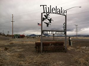
Welcome sign, south Tulelake
|
|
 Location in Siskiyou County and the state of California |
|
| Location in the United States | |
| Coordinates: 41°57′15″N 121°28′33″W / 41.95417°N 121.47583°WCoordinates: 41°57′15″N 121°28′33″W / 41.95417°N 121.47583°W | |
| Country | |
| State |
|
| County |
|
| Incorporated | March 1, 1937 |
| Area | |
| • Total | 0.412 sq mi (1.067 km2) |
| • Land | 0.410 sq mi (1.061 km2) |
| • Water | 0.002 sq mi (0.006 km2) 0.58% |
| Elevation | 4,035 ft (1,230 m) |
| Population (2010) | |
| • Total | 1,010 |
| • Density | 2,500/sq mi (950/km2) |
| Time zone | Pacific (PST) (UTC-8) |
| • Summer (DST) | PDT (UTC-7) |
| ZIP code | 96134 |
| Area code(s) | 530 |
| FIPS code | 06-80686 |
| GNIS feature ID | 1660040 |
Tulelake (/ˈtuːlileɪk/ TOO-lee-layk) is a city in Northeastern Siskiyou County, California, United States, at an elevation of 4,066 feet (1,239 m) above sea level. The town is named after nearby Tule Lake. The population was 1,010 at the 2010 census, down from 1,020 at the 2000 census.
The first public auction of Tulelake land parcels took place on April 15, 1931. Over 100 lots were sold for prices ranging from $65 to $350. In 1937, the city was incorporated. Today there are over 400 housing units.
Tulelake is located at 41°57′15″N 121°28′33″W / 41.95417°N 121.47583°W (41.954029, -121.475906). Tulelake is located near the Siskiyou-Modoc County line. At the northwest corner of the Great Basin and Range.
According to the United States Census Bureau, the city has a total area of 0.4 square miles (1.0 km2), 99.42% of it land and 0.58% of it water.
Tulelake has a steppe climate (BSk) according to the Köppen climate classification system.
...
Wikipedia

