Tuggeranong (district)
|
Tuggeranong Australian Capital Territory |
|||||||||||||||
|---|---|---|---|---|---|---|---|---|---|---|---|---|---|---|---|

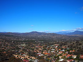
The view from Mount Wanniassa, looking down into the Tuggeranong Valley in 2013.
|
|||||||||||||||

Location of Tuggeranong, shaded.
|
|||||||||||||||
| Coordinates | 35°25′28″S 149°05′20″E / 35.4244°S 149.0888°ECoordinates: 35°25′28″S 149°05′20″E / 35.4244°S 149.0888°E | ||||||||||||||
| Population | 85,154 (2016 census) | ||||||||||||||
| Gazetted | 12 May 1966 | ||||||||||||||
| Location | 22 km (14 mi) SSW of Canberra City | ||||||||||||||
| Territory electorate(s) | |||||||||||||||
| Federal Division(s) | Canberra | ||||||||||||||
|
|||||||||||||||
The District of Tuggeranong is one of the original eighteen districts of the Australian Capital Territory used in land administration. The district is subdivided into divisions (suburbs), sections and blocks and is the southernmost town centre of Canberra, the capital city of Australia. The district comprises nineteen suburbs and occupies 117 square kilometres (45 sq mi) to the east of the Murrumbidgee River.
The name Tuggeranong is derived from a Ngunnawal expression meaning "cold place". From the earliest colonial times, the plain extending south into the centre of the present-day territory was referred to as Tuggeranong.
At the 2016 census, the population of the district was 85,154.
The traditional custodians of the district are the indigenous people of the Ngunawal tribe.
Following the transfer of land from the Government of New South Wales to the Commonwealth Government in 1911, the district was established in 1966 by the Commonwealth via the gazettal of the Districts Ordinance 1966 No. 5 (Cth) which, after the enactment of the Australian Capital Territory (Self-Government) Act 1988 (Cth), became the Districts Act 1966 No. 5 (ACT). This Act was subsequently repealed by the ACT Government and the district is now administered subject to the Districts Act 2002 (ACT).
...
Wikipedia
