Brindabella electorate
|
Brindabella Australian Capital Territory—Legislative Assembly |
|
|---|---|
 |
|
| Territory | Australian Capital Territory |
| Created | 1995 |
| Electors | 53,614 (2016) |
| Area | 1,588 km2 (613.1 sq mi) |
| Coordinates | 35°36′49″S 148°57′32″E / 35.61361°S 148.95889°ECoordinates: 35°36′49″S 148°57′32″E / 35.61361°S 148.95889°E |
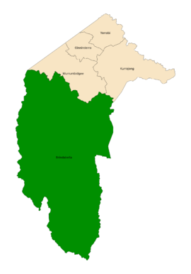
The Brindabella electorate is one of the five electorates for the unicameral 25-member Australian Capital Territory Legislative Assembly. It elects five members, and is the largest of the electorates in geographic area.
It was created in 1995, when the three-electorate, Hare-Clark electoral system was first introduced for the Australian Capital Territory (ACT). Prior to 1995, a multi-member single constituency existed for the whole of the ACT. "Brindabella" is derived from an indigenous word meaning "two kangaroo rats" and refers to the mountain range to the south and west of the ACT.
The Brindabella electorate consists of the large part of the ACT south of the Murrumbidgee River, although this region is sparsely inhabited.
From 1995 to 2008 it contained the Canberra district of Tuggeranong, excluding Hume, and the Woden Valley suburbs of Chifley, Pearce and Torrens.
In 2008, a boundary re-distribution by the Australian Capital Territory Electoral Commission, resulted in the electorate covering the Woden Valley suburb of Farrer.
In the 2016 redistribution, the Woden Valley suburbs, the village of Uriarra, and the suburb of Kambah were transferred into the Murrumbidgee electorate.
...
Wikipedia
