Tsuchiura
|
Tsuchiura 土浦市 |
|||
|---|---|---|---|
| City | |||

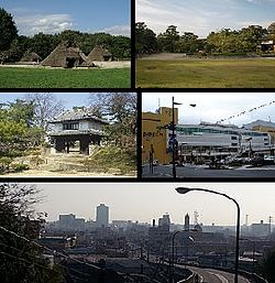
Upper: Kijo Park
Middle:Tsuchiura Castle, Tsuchiura Station Lower:Skyline |
|||
|
|||
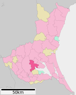
 Location of Tsuchiura in Ibaraki Prefecture |
|||
| Coordinates: 36°4′N 140°12′E / 36.067°N 140.200°ECoordinates: 36°4′N 140°12′E / 36.067°N 140.200°E | |||
| Country | Japan | ||
| Region | Kantō | ||
| Prefecture | Ibaraki Prefecture | ||
| Area | |||
| • Total | 122.89 km2 (47.45 sq mi) | ||
| Population (September 2015) | |||
| • Total | 141,181 | ||
| • Density | 1,150/km2 (3,000/sq mi) | ||
| Time zone | Japan Standard Time (UTC+9) | ||
| - Tree | Populus, Zelkova serrata | ||
| - Flower | Sakura | ||
| - Bird | Great reed warbler, Bush warbler | ||
| Phone number | 029-826-1111 | ||
| Address | 9-1 Yamato-cho, Tsuchiura-shi, Ibaraki-ken 300-8686 | ||
| Website | Official website | ||
Tsuchiura (土浦市 Tsuchiura-shi?) is a city located in Ibaraki Prefecture, in the northern Kantō region of Japan. As of September 2015, the city had an estimated population of 141,181 and a population density of 1510 persons per km². Its total area was 122.89 km². About 3,000 residents are non-Japanese, including a large proportion of Filipinos, Chinese, and Brazilians.
Located in southwestern Ibaraki Prefecture, Tsuchiura is situated along the western shores of Lake Kasumigaura, the second largest lake in Japan. The Tokyo metropolis lies about 60 km to the south, and Tsukuba science city borders Tsuchiura to the west.
Human settlement in the Tsuchiura area dates to the Japanese Paleolithic period, Hunter-gatherers inhabited the coastal area of the Pacific Ocean (now Lake Kasumigaura) forming large shell middens, examples of which can be seen at the Kamitakatsu archeological site. Locals began wet-rice cultivation and develop iron and bronze technology during the Yayoi period and in the Kofun period numerous Burial mounds were constructed in the area. During the Nara period the area was organized under the [Code of Taiho|Taihō Code]] with what is now Tsuchiura occupying four districts of Hitachi Province. In the Heian period, In 939, Taira no Masakado lead an uprising against the central government by attacking the provincial capital at Ishioka, a few kilometers to the north of Tsuchiura. During the Kamakura period and Sengoku period, the area was dominated by several samurai clans During the Edo period, parts of what is now Tsuchiura was administered as a castle town by Tsuchiura Domain, one of the feudal domains of the Tokugawa shogunate. The area prospered due to its position on the Mito Kaido, a highway connecting Edo with Mito and with a canal connecting Lake Kasumigaura to Edo Bay.
...
Wikipedia


