Truckee River
| Truckee River | |
| Salmon Trout River | |
|
The Truckee River just east of Truckee, California
|
|
| Name origin: Named after the Paiute chief Truckee | |
| Country | United States |
|---|---|
| States | California, Nevada |
| Source | Lake Tahoe |
| - location | Sierra Nevada, California |
| - elevation | 6,233 ft (1,900 m) |
| - coordinates | 39°10′3″N 120°8′39″W / 39.16750°N 120.14417°W |
| Mouth | Pyramid Lake |
| - elevation | 3,793 ft (1,156 m) |
| - coordinates | 39°51′27″N 119°26′53″W / 39.85750°N 119.44806°WCoordinates: 39°51′27″N 119°26′53″W / 39.85750°N 119.44806°W |
| Length | 121 mi (195 km) |
| Basin | 3,060 sq mi (7,925 km2) |
| Discharge | for USGS gage 10350000, Truckee River at Vista, NV |
| - average | 804 cu ft/s (23 m3/s) |
| - max | 17,400 cu ft/s (493 m3/s) |
| - min | 7 cu ft/s (0 m3/s) |
|
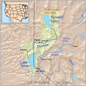
Map of the Pyramid Lake drainage basin
|
|
The Truckee River is a stream in the U.S. states of California and Nevada. The river flows northeasterly and is 121 miles (195 km) long. The Truckee is the sole outlet of Lake Tahoe and drains part of the high Sierra Nevada, emptying into Pyramid Lake in the Great Basin. Its waters are an important source of irrigation along its valley and adjacent valleys.
When John C. Frémont and Kit Carson ascended the Truckee River on January 16, 1844 they called it the Salmon Trout River, after the huge Lahontan cutthroat trout (Oncorhynchus clarki henshawi) that ran up the river from Pyramid Lake to spawn. However, the river was ultimately named after a Paiute chief known as Truckee who in 1844 guided an emigrant party from the headwaters of the Humboldt River to California via the Truckee River, Donner Lake, and Donner Pass. Appreciative of their Indian guide's services the party named the river after him. The chief's real name might not have been Truckee, but perhaps Tru-ki-zo, which could have become distorted as "Truckee". There are numerous other theories about Chief Truckee and his name.
The Truckee River's source is the outlet of Lake Tahoe, at the dam on the northwest side of the lake near Tahoe City, California. It flows generally northeast through the mountains to Truckee, California, then turns sharply to the east and flows into Nevada, through Reno and Sparks and along the northern end of the Carson Range. At Fernley it turns north, flowing along the east side of the Pah Rah Range. It empties into the southern end of Pyramid Lake, a remnant of prehistoric Lake Lahontan, in northern Washoe County in the Pyramid Lake Indian Reservation.
...
Wikipedia


