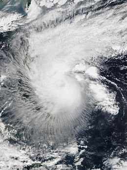
Tropical Storm Mekkhala (2015)
| Severe tropical storm (JMA scale) | |
|---|---|
| Category 1 (Saffir–Simpson scale) | |

Severe Tropical Storm Mekkhala at peak intensity on January 17
|
|
| Formed | January 13, 2015 |
| Dissipated | January 21, 2015 |
| Highest winds |
10-minute sustained: 110 km/h (70 mph) 1-minute sustained: 130 km/h (80 mph) |
| Lowest pressure | 975 hPa (mbar); 28.79 inHg |
| Fatalities | 3 total |
| Damage | $7.8 million (2015 USD) |
| Areas affected | Caroline Islands, Philippines |
| Part of the 2015 Pacific typhoon season | |
Severe Tropical Storm Mekkhala, known in the Philippines as Tropical Storm Amang, was an early-season tropical cyclone that made landfall over the Philippines in January 2015. Mekkhala killed three people in the Bicol Region and caused light crop damage. Notably, the storm disturbed Pope Francis’ visit to the country after the victims of Typhoon Haiyan on November 8, 2013. Although the storm also caused an airplane crash in Tacloban, nobody was hurt in the incident.
The system developed on January 13 between the Philippines and Guam. Moving west-northwest for its duration, Mekkhala passed north of Yap State on January 14 while slowly intensifying due to moderate wind shear. Conditions became more favorable on January 16, when the storm quickly strengthened to peak winds of at least 110 km/h (70 mph); a ragged eye prompted the American-based Joint Typhoon Warning Center (JTWC) to upgrade it to a typhoon. The storm weakened slightly and made landfall on the Philippine island of Samar on January 17. Mekkhala weakened further over land, dissipating on January 21 east of Luzon.
Tropical Storm Mekkhala was first noted as a tropical disturbance on January 11, while it was located within a marginal environment for further development, about 205 km (125 mi) to the south-southwest of Chuuk State in the Federated States of Micronesia. At this time the system's low level circulation centre was broad and ill defined, with a large band of deep atmospheric convection flaring along the centre's northern edge. Over the next day the system moved westwards into a more favourable environment, with atmospheric convection wrapping into a slowly-consolidating low-level circulation center. The Japan Meteorological Agency subsequently started to monitor the system as a tropical depression early on January 13. Later that day the United States Joint Typhoon Warning Center initiated advisories on the system and classified it as Tropical Depression 01W, despite tropical storm force winds of 65 km/h (40 mph) occurring on the northern side of the system.
...
Wikipedia
