Trawalla, Victoria
|
Trawalla Victoria |
|
|---|---|

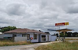
Raquel's Roadhouse on the Western Highway, now closed
|
|
| Coordinates | 37°26′S 143°28′E / 37.433°S 143.467°ECoordinates: 37°26′S 143°28′E / 37.433°S 143.467°E |
| Population | 224 (2006 census) |
| Established | 1839 |
| Postcode(s) | 3373 |
| Location | |
| LGA(s) | Pyrenees Shire |
| State electorate(s) | Ripon |
| Federal Division(s) | Wannon |
Trawalla is a town in central Western Victoria, Australia, located on the Western Highway, 41 kilometres (25 mi) west of Ballarat and 154 kilometres (96 mi) west of Melbourne, in the Shire of Pyrenees. At the 2006 census, Trawalla and the surrounding agricultural area had a population of 224.
Trawalla sits at the headwaters of the Mount Emu Creek where it crosses the Western Highway. The Ararat railway line passes through the area. A railway station was in service at Trawalla but closed in the 1960s. A local primary school, a roadhouse and the minimum security prison farm HM Prison Langi Kal Kal, are the focal points of the area. The Moner balug clan of the Wathaurong Aboriginal people called the area, Trawalla which means 'wild water' or possibly 'much rain'.
In 1836 the district was traversed and noted by explorer Sir Thomas Mitchell after ascending Mount Cole. The first European settlers to arrive in the area were squatters, Kenneth William Kirkland, his wife Katherine (née Hamilton) and daughter Agnes Anna, and Katherine's brothers Robert and James McGregor Hamilton, who established sheep and cattle grazing runs. Trawalla Station, was established by Hamilton in 1838 and acquired by Adolphus Goldsmith three years later. After passing through several owners the property was taken over by Rear Admiral Bridges in 1887. It was under his ownership that Trawalla House was constructed. Trawalla Post Office opened on 3 December 1864 at the time of closer settlement and closed 13 July 1974.
...
Wikipedia

