Touchet Formation
| Touchet Formation | |
|---|---|

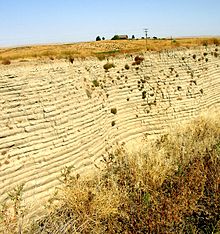
Touchet beds in the "Little Grand Canyon" near Lowden in the Walla Walla valley. Note distinct layers. |
|
| Type | Geological formation |
| Underlies | Loess |
| Overlies | Columbia River Basalt Group |
| Area | 7,000 square miles (18,000 km2) |
| Thickness | up to 330 feet (100 m) |
| Lithology | |
| Primary | sediment |
| Other | Basalt, Loess |
| Location | |
| Coordinates | Walla Walla Basin 46°15′49″N 120°31′00″W / 46.26361°N 120.51667°W Touchet Basin 46°06′00″N 118°39′00″W / 46.10000°N 118.65000°W White Bluffs 46°42′25″N 119°27′23″W / 46.70694°N 119.45639°W Yakima Basin 46°20′30″N 119°27′23″W / 46.34167°N 119.45639°W |
| Region |
Columbia Basin of Western North America |
| Country | USA |
| Type section | |
| Named for | Touchet, Washington |
| Named by | Richard Foster Flint, 1938 |
 Map showing the elevations of the Mid-Columbia region. The lowland areas in brown routinely were flooded during the Missoula Floods, creating lakes. |
|
The Touchet Formation or Touchet beds consist of large quantities of gravel and fine sediment which overlay almost a thousand meters (several thousand feet) of volcanic basalt of the Columbia River Basalt Group in south-central Washington and north-central Oregon. The beds consist of between 6 and 40 distinct rhythmites - horizontal layers of sediment, each clearly demarcated from the layer below. These Touchet beds are often covered by windblown loess soils which were deposited later; the number of layers varies with location. The beds vary in depth from 330 ft (100 m) at lower elevations where a number of layers can be found to a few extremely thin layers at the maximum elevation where they are observed (1,150 ft (350 m)).
The Touchet beds are one element in a chain of evidence which helped identify and define the progression of the Missoula Floods, which occurred around 16,450 to 13,750 years BCE. During the floods, flow through the Wallula Gap was slow enough such that water pooled in a temporary lake, Lake Lewis. Lake Lewis back-flooded up the Yakima, Walla Walla, Touchet and Tucannon River Valleys. In these relatively calm arms of the lake, the slack waters deposited the suspended materials eroded from the scabland regions north of Lake Lewis, and redeposited them in pronounced layers before receding.
Although visible along the Walla Walla and Touchet rivers, the Touchet Beds were not subjected to study until the early 20th century. They remain at the center of scientific analyses to characterize the Missoula Floods.
The type locality for the Touchet Formation is the confluence of the Touchet River with the Walla Walla River, originally noted by Richard Foster Flint in 1938. Numerous other exposures were subsequently identified throughout the basins of the former Lake Lewis and Lake Condon. Touchet-equivalent slackwater deposits are also present in the Willamette Valley near Portland (former Lake Allison).
...
Wikipedia
