Torreya State Park
| Torreya State Park | |
|---|---|
|
IUCN category V (protected landscape/seascape)
|
|

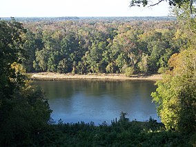
View of the Apalachicola River from bluffs
in Torreya State Park |
|
| Location | Liberty County, Florida, United States |
| Nearest city | Bristol, Florida |
| Coordinates | 30°34′08″N 84°56′53″W / 30.56889°N 84.94806°WCoordinates: 30°34′08″N 84°56′53″W / 30.56889°N 84.94806°W |
| Area | 13,735 acres (55.58 km2) |
| Governing body | Florida Department of Environmental Protection |
| Designated | December 1976 |
Torreya State Park is a 13,735 acre (56 km²) Florida State Park, U.S. National Natural Landmark and historic site thirteen miles (19 km) north of Bristol. It is located north of S.R 12 on the Apalachicola River, in northwestern Florida (Florida Panhandle), at 2576 N.W. Torreya Park Road.
It was named for the Florida Nutmeg (Torreya taxifolia) trees, a rare species of Torreya tree endemic to the local east bank of the Apalachicola River's limestone bluffs.
With river swamps and high pinelands, extensive ravines and high bluffs along the river, the park has one of the most variable terrains of any in Florida. The high elevation of the park is about 300 feet at the top of Logan Hill. Many streams run through the park
Prior Native American inhabitation has been confirmed by archaeological discoveries in the area.
In 1818, General Andrew Jackson and his army crossed the Apalachicola here during the first Seminole Indian War. Ten years later, the first government road to cross the new Territory met the river here.
Due to the river's importance during the Civil War, a six-cannon battery was placed on a bluff to prevent the passage of Union gunboats. These cannons never saw combat action at this location. The gun pit's remains can still be seen in the park.
...
Wikipedia

