Topoľčany
| Topoľčany | ||
| Town | ||
|
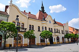
Town hall in Topoľčany
|
||
|
||
| Country | Slovakia | |
|---|---|---|
| Region | Nitra | |
| District | Topoľčany | |
| River | Nitra | |
| Elevation | 174 m (571 ft) | |
| Coordinates | 48°33′15″N 18°10′37″E / 48.55417°N 18.17694°ECoordinates: 48°33′15″N 18°10′37″E / 48.55417°N 18.17694°E | |
| Area | 27.576 km2 (10.647 sq mi) | |
| Population | 27,177 (2011 Population census) | |
| Density | 986/km2 (2,554/sq mi) | |
| First mentioned | 1173 | |
| Mayor | Peter Baláž | |
| Timezone | CET (UTC+1) | |
| - summer (DST) | CEST (UTC+2) | |
| Postal code | 95501 | |
| Area code | +421-38 | |
| Car plate | TO | |
| Statistics: MOŠ/MIS | ||
| Website: http://www.topolcany.sk | ||
Topoľčany ([ˈtopoʎtʃani]; Slovak: Veľké Topoľčany before 1920; Hungarian: Nagytapolcsány) is a town in the Nitra Region of Slovakia. The population as of 2006 was 28,685. The town's population is nicknamed Žochári (sing. Žochár) (producers, or owners of "mosses").
The Nitra river flows through a wide valley between the two mountain ranges which are visible from the town - Tribeč (east) and Považský Inovec (west).
The name Topoľčany was assumed to be derived from Slovak: topoľ (poplar tree). Groves of these trees were once abundant on the banks of the Nitra River, thus the local settlers get the name *Topoľčane - "those who live between poplars". However recent studies have shown that the name is derived from the Old Slavonic word topol meaning "warm, hot", for there were hot springs in the region in early medieval times.
Founded in the 9th century, Topoľčany was a regional market centre during the Middle Ages located on the western bank of the Nitra River and on a crossroads of trade routes.
Topoľčany Castle was built in the 13th century 18 km to the NW of the town; this considerable distance was due to the lowland location of Topoľčany. The castle lies on slopes of Považský Inovec.
During the 12th and 13th centuries, Topoľčany was owned by the Csak family, its most famous member being Matthew III Csák. In the 15th century, the castle was conquered and held by the Hussites for 3 years, who returned it for a fee of 9000 ducats in 1434. In 1443 the countryside was pillaged by a rogue noble who had captured the castle, but was later evicted by the king and sent to Moravia. In the same year, and again in 1444, the town (and much of Carpathia) was struck by an earthquake.
...
Wikipedia


