Top end
|
Top End Northern Territory |
|||||||
|---|---|---|---|---|---|---|---|

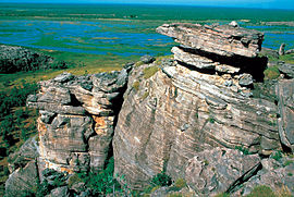
Wetlands in Kakadu National Park
|
|||||||

The approximate location of the Top End, shown in red, within the Northern Territory
|
|||||||
| Location of the Top End in Australia's Northern Territory | |||||||
| Coordinates | 13°53′0″S 133°0′0″E / 13.88333°S 133.00000°ECoordinates: 13°53′0″S 133°0′0″E / 13.88333°S 133.00000°E | ||||||
| Area | 400,000 km2 (154,440.9 sq mi) | ||||||
| Time zone | ACST (UTC+09:30) | ||||||
|
|||||||
The Top End of Australia's Northern Territory is a geographical region encompassing the northernmost section of the Northern Territory, which aside from the Cape York Peninsula is the northernmost part of the Australian continent. It covers a rather vaguely defined area of perhaps 400,000 km2 (154,441 sq mi) behind the northern coast from the Northern Territory capital of Darwin across to Arnhem Land with the Indian Ocean on the west, the Arafura Sea to the north, and the Gulf of Carpentaria to the east, and with the almost waterless semi-arid interior of Australia to the south, beyond the huge Kakadu National Park.
The Top End contains both of the Territory's cities and one of its major towns, Darwin, Palmerston and Katherine. The well-known town of Alice Springs is located further south, in the arid southern part of the Northern Territory, sometimes referred to by Australians as the Red Centre.
The landscape is relatively flat with river floodplains and grasslands with eucalyptus trees along with rocky areas and patches of rainforest, and in western Arnhem Land a high rugged sandstone plateau cut through with gorges, much of which is in Kakadu National Park. The rivers that form the wetlands include the South and East Alligator Rivers, Mary River, and the Glyde River. The climate is tropical monsoon with a wet and dry season, bringing the highest rainfall in northern Australia (over 1,200 mm (47 in) per year). Temperatures do not fluctuate widely throughout the year.
...
Wikipedia

