Tooele County, UT
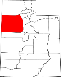
| Tooele County, Utah | |
|---|---|
 Location in the U.S. state of Utah |
|
 Utah's location in the U.S. |
|
| Founded | 1850/1851 |
| Seat | Tooele |
| Largest city | Tooele |
| Area | |
| • Total | 7,286 sq mi (18,871 km2) |
| • Land | 6,941 sq mi (17,977 km2) |
| • Water | 345 sq mi (894 km2), 4.7% |
| Population (est.) | |
| • (2015) | 62,952 |
| • Density | 8.4/sq mi (3/km²) |
| Congressional district | 2nd |
| Time zone | Mountain |
| Website | www |
Tooele County /tuːˈɪlə/ is a county in the U.S. state of Utah. As of the 2010 census, the population was 58,218. Its county seat and largest city is Tooele. The county was created in 1850 and organized the following year.
Tooele County is part of the Salt Lake City, UT Metropolitan Statistical Area. A 2008 CNNMoney.com article identified Tooele as the U.S. county experiencing the greatest job growth since 2000.
The western half is mostly covered by the famous Salt Lake. The eastern half across the mountains contains small towns outside of Salt Lake City as well as the Dugway Proving Ground.
Evidence of several indigenous Native American groups has been found in Tooele County, but only the western Shoshone-speaking Goshute tribe claim the desolate lands as their ancestral home. The Goshute's traditional territory includes most of modern Tooele County.
The Great Salt Lake Desert, which comprises much of the northern portion of the county, provided a major stumbling block for the ill-fated Donner-Reed Party in 1846. Its crusty sand slowed the group's wagons to such an extent that the group spent six days crossing its 80-mile length, severely sapping the group's resources.
...
Wikipedia
