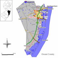
Toms River CDP, New Jersey
| Toms River, New Jersey | |
|---|---|
| Census-designated place | |

Downtown Toms River
|
|
 Map of Toms River CDP in Ocean County. Inset: Location of Ocean County in New Jersey. |
|
| Coordinates: 39°59′41″N 74°11′16″W / 39.994856°N 74.187754°WCoordinates: 39°59′41″N 74°11′16″W / 39.994856°N 74.187754°W | |
| Country |
|
| State |
|
| County | Ocean |
| Township | Toms River |
| Area | |
| • Total | 40.738 sq mi (105.510 km2) |
| • Land | 38.947 sq mi (100.871 km2) |
| • Water | 1.791 sq mi (4.639 km2) 4.40% |
| Elevation | 62 ft (19 m) |
| Population (2010 Census) | |
| • Total | 88,791 |
| • Density | 2,279.8/sq mi (880.2/km2) |
| Time zone | Eastern (EST) (UTC-5) |
| • Summer (DST) | Eastern (EDT) (UTC-4) |
| ZIP codes | 08753-08757 |
| Area code(s) | 732/848 |
| FIPS code | 3473110 |
| GNIS feature ID | 02390394 |
Toms River is an unincorporated community and census-designated place (CDP) located within Toms River Township (formerly Dover Township), in Ocean County, New Jersey, United States. As of the 2010 United States Census, the CDP's population was 88,791. It is the county seat of Ocean County. The area is named for Toms River, whose estuary flows through the community and empties into Barnegat Bay.
Toms River Township and the census-designated place are not co-extensive. In addition to the census-designated place, which includes all of mainland Toms River Township, Toms River Township includes two small CDPs: Dover Beaches North (2010 Census population of 1,239) and Dover Beaches South (1,209), both of which are located on the Barnegat Peninsula. As defined by the Census Bureau based on 2010 Census data, more than 96% of Toms River Township's area and of its population of 91,239 was located in Toms River CDP.
According to the United States Census Bureau, the CDP had a total area of 40.738 square miles (105.510 km2), including 38.947 square miles (100.871 km2) of land and 1.791 square miles (4.639 km2) of water (4.40%).
As of the 2010 United States Census, there were 88,791 people, 33,394 households, and 23,643 families residing in the CDP. The population density was 2,279.8 per square mile (880.2/km2). There were 36,605 housing units at an average density of 939.9 per square mile (362.9/km2). The racial makeup of the CDP was 89.71% (79,653) White, 2.77% (2,459) Black or African American, 0.17% (151) Native American, 3.67% (3,260) Asian, 0.02% (17) Pacific Islander, 1.98% (1,760) from other races, and 1.68% (1,491) from two or more races. Hispanic or Latino of any race were 8.04% (7,136) of the population.
...
Wikipedia
