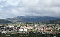
Tlaxco Municipality, Tlaxcala
| Tlaxco | ||
|---|---|---|
| Municipality | ||

The town and municipal seat of Tlaxco
|
||
|
||
 Location in Tlaxcala |
||
| Location in Mexico | ||
| Coordinates: 19°36′50″N 98°07′07″W / 19.61389°N 98.11861°WCoordinates: 19°36′50″N 98°07′07″W / 19.61389°N 98.11861°W | ||
| Country |
|
|
| State |
|
|
| Established | 29 August 1945 | |
| Seat | Tlaxco | |
| Government | ||
| • President | Gardenia Hernández Rodríguez | |
| Area | ||
| • Total | 575 km2 (222 sq mi) | |
| Elevation (of seat) | 2,553 m (8,376 ft) | |
| Highest elevation (Cerro Peñas Coloradas) | 3,360 m (11,020 ft) | |
| Population (2010 Census) | ||
| • Total | 39,939 | |
| • Estimate (2015 Intercensal Survey) | 42,536 | |
| • Density | 69/km2 (180/sq mi) | |
| • Seat | 14,806 | |
| Time zone | Central (UTC-6) | |
| • Summer (DST) | Central (UTC-5) | |
| Postal code of seat | 90250 | |
| Area code | 241 | |
| Website | Official website | |
Tlaxco (Nahuatl: "place of the ball game") is a municipality in Tlaxcala, Mexico.
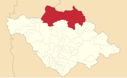
The municipality of Tlaxco is located in northern Tlaxcala on the border with Hidalgo and Puebla. From east to west on its northern side, it borders the municipalities of Ixtacamaxtitlán and Chignahuapan in Puebla, and Almoloya and Apan in Hidalgo. From east to west on its southern side, it borders the Tlaxcalan municipalities of Emiliano Zapata, Lázaro Cárdenas, Tetla de la Solidaridad, Atlangatepec, Muñoz de Domingo Arenas, Hueyotlipan and Benito Juárez. Tlaxco is Tlaxcala's largest municipality: it covers an area of 575 square kilometres (222 sq mi) and comprises 14.40% of the state's area.
Situated in the Mexican Altiplano, Tlaxco lies at an average altitude of 2,540 metres (8,330 ft) above sea level. The western and central parts of the municipality are relatively flat, while the northern and eastern parts of the municipality feature more rugged terrain. The highest point in the municipality is the Cerro Peñas Coloradas located at 19°39′55″N 98°03′11″W / 19.6653°N 98.0531°W with an elevation of 3,360 metres (11,020 ft) above sea level. The Zahuapan River and its tributaries drain the central-eastern part of the municipality.. There are also two reservoirs in the municipality, Lázaro Cárdenas in the extreme east and El Muerto in the west. Agricultural land comprises 65.43% of the municipality. Soils in the municipality include cambisols, fluvisols, lithosols, gleysols and andosols.
...
Wikipedia


