Tlalpujahua
| Tlalpujahua (de Rayón) | |
|---|---|
| Town & Municipality | |

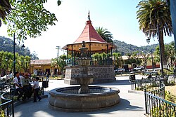
Kiosk in the center of Tlalpujahua
|
|
| Location in Mexico | |
| Coordinates: 19°48′18″N 100°10′28″W / 19.80500°N 100.17444°WCoordinates: 19°48′18″N 100°10′28″W / 19.80500°N 100.17444°W | |
| Country |
|
| State | Michoacán |
| Founded | 1560 |
| Municipal Status | 1822 |
| Government | |
| • Municipal President | Moises García Alvarado |
| Area | |
| • Municipality | 190.86 km2 (73.69 sq mi) |
| Elevation (of seat) | 2,580 m (8,460 ft) |
| Population (2005) Municipality | |
| • Municipality | 25,373 |
| • Seat | 3,704 |
| Time zone | CST (UTC-6) |
| Postal code (of seat) | 61060 |
| Website | Template:Esicon Website |
Tlalpujahua (Spanish ![]() [tlapuxa'wa] ; formally Tlalpujahua de Rayón) is a town and municipality located in the far northeast of the state of Michoacán in central Mexico. It is a former mining town, home of the Dos Estrellas Mine, which was the leading producer of gold in the early 20th century. A major landslide of mud and mining debris damaged this mine and buried about one-third of the town in 1937, effectively ending mining. In the 1960s, a local by the name of Joaquín Muñoz Orta began making Christmas tree ornaments here. This eventually grew into what is now one of the largest producers of ornaments called Adornos Navideños SA de CV. In addition to this and another factory, there are about 150 small workshops dedicated to making Christmas items, with about 70% of the town’s economy based on it. In 2005, the town, with its narrow stone streets and adobe/stone houses with red tile roofs, was made a Pueblo Mágico as part of its efforts to attract tourism.
[tlapuxa'wa] ; formally Tlalpujahua de Rayón) is a town and municipality located in the far northeast of the state of Michoacán in central Mexico. It is a former mining town, home of the Dos Estrellas Mine, which was the leading producer of gold in the early 20th century. A major landslide of mud and mining debris damaged this mine and buried about one-third of the town in 1937, effectively ending mining. In the 1960s, a local by the name of Joaquín Muñoz Orta began making Christmas tree ornaments here. This eventually grew into what is now one of the largest producers of ornaments called Adornos Navideños SA de CV. In addition to this and another factory, there are about 150 small workshops dedicated to making Christmas items, with about 70% of the town’s economy based on it. In 2005, the town, with its narrow stone streets and adobe/stone houses with red tile roofs, was made a Pueblo Mágico as part of its efforts to attract tourism.
The town proper is small with only 3,704 residents (2005). It is filled with stone paved streets which rise and fall markedly, with the rugged terrain it is built on. Along the streets there are houses with thick walls made of adobe and/or pink sandstone, topped with peaked roofs covered in red tile. A number has wooden balconies and other wood details and look like chalets. The houses are built this way due to the winter months which are cold and sometimes snowy. (decarlan) Surrounding the town are rugged forested mountains. In 2005, Tlalpujahua became the 20th town to be declared a Pueblo Mágico, as part of its efforts to attract tourism. However, it is still quiet with few traffic problems despite the narrow streets.
Tlalpujahua’s history is tied to mining, with the peak period for this activity spanning the very late 19th century to the 1930s, although mining had been done in this area since pre-Hispanic times. The major mine of the area was the Dos Estrellas Mine, which was established when a miner by the name of Nacho Ramírez found a rich vein, while employed by Frenchman Francois Joseph Fournier in 1898. This mine was the largest producer of gold, producing 45,000 kg (44 long tons; 50 short tons) of gold and 400,000 kg (394 long tons; 441 short tons) of silver until a major landslide ended mining here in 1937. Today, the mine has been converted into a museum called the Museo Tecnológico Minero Siglo 19. The exhibits are housed in the mine’s original buildings, almost all of which have been preserved. The mine museum contains mining equipment and a collection of old photographs depicting the life and times of the area during its mining heyday, and is the first of its kind in Mexico. Some of the buildings also hold workshops and other events and others have been left as they were, such as the old mechanics shop, which is claimed to be where parts of the first airplane made in Mexico were forged. The garden areas of the museum contain sculptures made with materials found in the mine in forms such as butterflies and erupting volcanoes. They were made by Gustavo Bernal, the director of the museum and the one to bring the museum into existence. The museum also has a bookshop and café.http://www.museominadosestrellas.com.mx
...
Wikipedia

