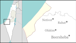
Tkuma, Israel
|
Tkuma תקומה |
|
|---|---|

Village synagogue
|
|
| Coordinates: 31°27′4.32″N 34°32′42″E / 31.4512000°N 34.54500°ECoordinates: 31°27′4.32″N 34°32′42″E / 31.4512000°N 34.54500°E | |
| District | Southern |
| Council | Sdot Negev |
| Affiliation | Hapoel HaMizrachi |
| Founded | 5–6 October 1946 |
| Founded by | Eastern European Jews |
| Population (2016) | 666 |
Tkuma (Hebrew: תְּקוּמָה, lit. Resurrection) is a religious moshav in southern Israel. Located north-west of Netivot, it falls under the jurisdiction of Sdot Negev Regional Council. In 2016 it had a population of 666.
Tkuma was established as a kibbutz on the night of 5 and 6 October 1946 as one of the 11 points in the Negev at a location around a mile from the present site. The first residents were Jewish immigrants from Eastern Europe, who survived the Holocaust, and the village's name reflects the resurrection of Israel.
In 1949 the village moved to its present location near the site of the depopulated Arab village of al-Muharraqa. According to Morris, Tkuma is near the al-Muharraqa site, but according to Khalidi, Tkuma, although only 2 km west of the al-Muharraqa site, is actually on land which formally belonged to the city of Gaza.
In the 1950s the moshav was joined by more immigrants from Eastern Europe and Tunisia.
Located 5 kilometers from Gaza, the moshav has suffered damage from rockets launched by Hamas militants during 2000s and 2010s. The moshav is serviced by the Color Red alert system.
...
Wikipedia

