Tisbury, Massachusetts
| Tisbury, Massachusetts | ||
|---|---|---|
| Town | ||

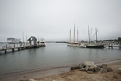
Vineyard Haven Harbor
|
||
|
||
 Location in Dukes County in Massachusetts |
||
| Coordinates: 41°27′22″N 70°36′40″W / 41.45611°N 70.61111°WCoordinates: 41°27′22″N 70°36′40″W / 41.45611°N 70.61111°W | ||
| Country | United States | |
| State | Massachusetts | |
| County | Dukes | |
| Settled | 1660 | |
| Incorporated | 1671 | |
| Government | ||
| • Type | Open town meeting | |
| Area | ||
| • Total | 19.1 sq mi (49.5 km2) | |
| • Land | 6.5 sq mi (16.9 km2) | |
| • Water | 12.6 sq mi (32.6 km2) | |
| Elevation | 89 ft (27 m) | |
| Population (2010) | ||
| • Total | 3,949 | |
| • Density | 604/sq mi (233.3/km2) | |
| Time zone | Eastern (UTC-5) | |
| • Summer (DST) | Eastern (UTC-4) | |
| ZIP code | 02568 | |
| Area code(s) | 508 / 774 | |
| FIPS code | 25-69940 | |
| GNIS feature ID | 0619443 | |
| Website | www |
|
Tisbury is a town located on Martha's Vineyard in Dukes County, Massachusetts, United States. The population was 3,949 at the 2010 census.
Vineyard Haven is the main village/town center of Tisbury. The two names are used interchangeably. As can be seen in the history section below, the town of Tisbury was incorporated within the Commonwealth of Massachusetts in 1671 and remains the legal name of the town to this day. However, the port and harbor have had varying names. "Holmes Hole" was one of the first names of the port within the town of Tisbury. This name was later changed to "Vineyard Haven", which is the official post office name for the community. To residents of Martha's Vineyard, "Vineyard Haven" is by far the more common usage, although residents recognize Tisbury as the town's legal name.
Vineyard Haven in Tisbury is the main port of entrance to Martha's Vineyard and is the only operational port on the island during most of the year.
Martha's Vineyard was discovered by the English maritime explorer Bartholomew Gosnold in 1602. Six decades later, in 1660, Tisbury was first settled by James Allen, William Peabody and Lt. Josiah Standish, a son of Captain Myles Standish. It was officially incorporated in 1671 by Francis Lovelace, Governor General of New York. The town, which originally included the lands of West Tisbury, was named for Tisbury, Wiltshire, England, the hometown of Martha's Vineyard Governor Mayhew. Citizens of the island, unhappy with the leadership of Governor Mayhew, petitioned William and Mary in 1673 for a change of leadership. It was then that the town, as well as the entire island, became a part of Massachusetts.
The town was divided into its current boundaries in 1892.
The town has long thrived on the sea and is now the home of the main ferry docks for the island. The island's first and primary ferry line is the Steamship Authority, which runs to and from Woods Hole, New Bedford, and Nantucket (in the summer months from the Oak Bluffs terminal), all in Massachusetts. There are several other private ferry lines that serve Martha's Vineyard as well, with terminals in the towns of Oak Bluffs and Edgartown. To get an idea of the embarkation in summer of passengers, tourists primarily, and goods, see the early scene in the movie Jaws which shows the debarkation on "Amity Island" of a typical boatload in summer at the Vineyard Haven Steamship Authority facility from the steamship Naushon. At the time of the filming of Jaws in 1975 this was the largest of the ferries, running only in the summer months for its high passenger capacity. It ceased service in 1987 and has been replaced by more modern vessels.
...
Wikipedia

