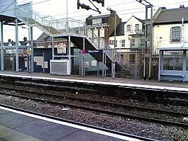
Tilbury Town railway station
| Tilbury Town |
|
|---|---|
 |
|
| Location | |
| Place | Tilbury |
| Local authority | Thurrock |
| Grid reference | TQ636763 |
| Operations | |
| Station code | TIL |
| Managed by | c2c |
| Number of platforms | 2 |
| DfT category | D |
| Live arrivals/departures, station information and onward connections from National Rail Enquiries |
|
| Annual rail passenger usage* | |
| 2011/12 |
|
| 2012/13 |
|
| 2013/14 |
|
| 2014/15 |
|
| 2015/16 |
|
| History | |
| 15 June 1885 | Opened as Tilbury Dock |
| December 1934 | Renamed Tilbury Town |
| 1992 | Tilbury Riverside closed |
| National Rail – UK railway stations | |
| * Annual estimated passenger usage based on sales of tickets in stated financial year(s) which end or originate at Tilbury Town from Office of Rail and Road statistics. Methodology may vary year on year. | |
|
|
|
Tilbury Town railway station is on a loop line on the London, Tilbury and Southend Railway, serving the town of Tilbury, Essex. It is 21 miles 48 chains (34.8 km) down-line from London Fenchurch Street via Rainham and it is situated between Grays and East Tilbury. Its three-letter station code is TIL.
The station was opened on 15 June 1885 with the name Tilbury Dock. It was renamed Tilbury Town in December 1934. It is on a link known as the Tilbury Loop, which joins the main line at the London end at Barking and at the country end at Pitsea. A bus link is provided for the Gravesend ferry, replacing the rail link to Tilbury Riverside which was closed in 1992.
Today, the station and all trains serving it are operated by c2c.
The typical off-peak service consists of:
The station plays two roles in the 2009 film Fish Tank – it appears in the film, and the star, Katie Jarvis, was recruited after a scout saw her arguing with her boyfriend at Tilbury Town station.
The station and its environs in the Victorian era are also mentioned briefly in Robert Roberts' 1895 book Diary of a Voyage to Australia, New Zealand, and Other Lands, written a mere 10 years after the station opened.
Coordinates: 51°27′43″N 0°21′14″E / 51.462°N 0.354°E
...
Wikipedia
