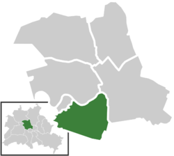
Tiergarten, Berlin
| Tiergarten | ||
|---|---|---|
| Quarter of Berlin | ||
|
||
| Coordinates: 52°31′00″N 13°22′00″E / 52.51667°N 13.36667°ECoordinates: 52°31′00″N 13°22′00″E / 52.51667°N 13.36667°E | ||
| Country | Germany | |
| State | Berlin | |
| City | Berlin | |
| Borough | Mitte | |
| Founded | 1861 | |
| Area | ||
| • Total | 5.17 km2 (2.00 sq mi) | |
| Population (2009-06-30) | ||
| • Total | 12,486 | |
| • Density | 2,400/km2 (6,300/sq mi) | |
| Time zone | CET/CEST (UTC+1/+2) | |
| Postal codes | (nr. 0104) 10557, 10785, 10787 | |
| Vehicle registration | B | |
Tiergarten (German for Animal Garden) is a locality within the borough of Mitte, in central Berlin (Germany). Notable for the great and homonymous urban park, before German reunification, it was a part of West Berlin. Until Berlin's 2001 administrative reform, Tiergarten was also the name of a borough, consisting of the current Bezirk of Tiergarten (formerly called Tiergarten-Süd) plus Hansaviertel and Moabit. A new system of road and rail tunnels runs under the park towards Berlin's main station in nearby Moabit.
Once a hunting ground of the Electors of Brandenburg the Großer Tiergarten park of today was designed in the 1830s by landscape architect Peter Joseph Lenné. In the course of industrialization in the 19th century, a network of streets was laid out in the Hobrecht-Plan in an area that came to be known architecturally as the Wilhelmine Ring. In 1894 the Reichstag building by architect Paul Wallot opened as the seat of the German parliament. The lawn between the contemporary Haus der Kulturen der Welt (House of World Cultures) and the Reichstag building was the site of the Krolloper opera house, built in 1844, which served as parliament house after the Reichstag fire on 27 February 1933 and was demolished by air raids in 1943.
...
Wikipedia


