
Tiefenthal
| Tiefenthal | ||
|---|---|---|
|
||

Tiefenthal
|
||
|
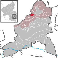
Location of Tiefenthal within Bad Dürkheim district
  |
||
| Coordinates: 49°32′18″N 08°06′14″E / 49.53833°N 8.10389°ECoordinates: 49°32′18″N 08°06′14″E / 49.53833°N 8.10389°E | ||
| Country | Germany | |
| State | Rhineland-Palatinate | |
| District | Bad Dürkheim | |
| Municipal assoc. | Hettenleidelheim | |
| Government | ||
| • Mayor | Edwin Gaub (CDU) | |
| Area | ||
| • Total | 4.21 km2 (1.63 sq mi) | |
| Elevation | 290 m (950 ft) | |
| Population (2015-12-31) | ||
| • Total | 842 | |
| • Density | 200/km2 (520/sq mi) | |
| Time zone | CET/CEST (UTC+1/+2) | |
| Postal codes | 67311 | |
| Dialling codes | 06351 | |
| Vehicle registration | DÜW | |

Tiefenthal is an Ortsgemeinde – a municipality belonging to a Verbandsgemeinde, a kind of collective municipality – in the Bad Dürkheim district in Rhineland-Palatinate, Germany.
The municipality lies in a small hollow with northern slopes between the Eisbach and Eckbach valleys in the Palatinate. Tiefenthal belongs to the Verbandsgemeinde of Hettenleidelheim, whose seat is in the like-named municipality. Until 1969, the municipality belonged to the now abolished district of Frankenthal.
In 1318, the municipality had its first documentary mention as Dyfendal.
In 2007, 45.4% of the inhabitants were Evangelical and 35.4% Catholic. The rest belonged to other faiths or adhered to none.
The council is made up of 12 council members, who were elected at the municipal election held on 7 June 2009, and the honorary mayor as chairman.
The municipal election held on 7 June 2009 yielded the following results:
The German blazon reads: In Rot ein goldenes Tatzenkreuz.
The municipality’s arms might in English heraldic language be described thus: Gules a cross pattée humetty Or.
The arms were approved by the now defunct Regierungsbezirk administration in Neustadt and date from a 1724 seal. They are borrowed from the arms once borne by the Counts of Leiningen-Westerburg, to whom Tiefenthal belonged.
A few kilometres away lies the Wattenheim interchange on the Autobahn A 6. Historically, a branch of the Eis Valley Railway once linked the municipality with Grünstadt.
...
Wikipedia