Thurstaston
| Thurstaston | |
|---|---|
| Village | |
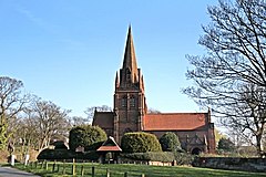
 St Bartholomew's Church, Thurstaston |
|
| Thurstaston shown within Merseyside | |
| Population | 160 (2001 Census) |
| OS grid reference | SJ246839 |
| • London | 179 mi (288 km) SE |
| Metropolitan borough | |
| Metropolitan county | |
| Region | |
| Country | England |
| Sovereign state | United Kingdom |
| Post town | WIRRAL |
| Postcode district | CH61 |
| Dialling code | 0151 |
| ISO 3166 code | GB-WRL |
| Police | Merseyside |
| Fire | Merseyside |
| Ambulance | North West |
| EU Parliament | North West England |
| UK Parliament | |
Thurstaston is a village on the Wirral Peninsula, England. It is part of the West Kirby & Thurstaston Ward of the Metropolitan Borough of Wirral. The village lies on the A540 road between Heswall and Caldy, although it extends some distance down Station Road to the bank of the Dee estuary where there is a large caravan park.
At the time of the 2001 Census, the village itself had only 160 inhabitants, although the national census included Caldy and parts of Irby, bringing the total population to 15,548.
Thurstaston means "village of a man called Thorsteinn/Þorsteinn", from the Old Norse personal name Thorsteinn/Þorsteinn and Old English tún "farm, village". A record of the name as Torstestiune in 1048 proves this origin. The village was mentioned in the Domesday Book as Turstanetone. Historically and popularly, the name was wrongly thought to refer to "Thor's Stone", a sandstone outcrop on Thurstaston Common.
A Viking settlement called Straumby once existed in Tinker's Dale, near the modern-day Thurstaston Visitor Centre.
Thurstaston, including the hamlet of Dawpool, was a parish within the Wirral Hundred, in the county of Cheshire. The population was 112 in 1801, 98 in 1851, 141 in 1901 and 151 in 1951.
...
Wikipedia

