Thorp, Washington
|
Thorp, Washington (Native American Name: Klála) |
|
|---|---|
| unincorporated community & census-designated place | |

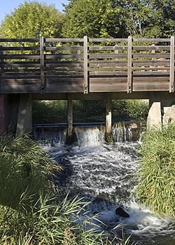
Millrace weir at the historic Thorp Mill.
|
|
 Location of Thorp, Washington |
|
| Location in the United States | |
| Coordinates: 47°4′5″N 120°40′22″W / 47.06806°N 120.67278°WCoordinates: 47°4′5″N 120°40′22″W / 47.06806°N 120.67278°W | |
| Country |
|
| State |
|
| County | Kittitas |
| Settled | 1868 |
| Platted | July 9, 1895 |
| Named for | Fielden Mortimer Thorp |
| Area | |
| • Total | 1.2 sq mi (3.2 km2) |
| • Land | 1.2 sq mi (3.2 km2) |
| • Water | 0.0 sq mi (0.0 km2) |
| Elevation | 1,637 ft (499 m) |
| Population (2010) | |
| • Total | 240 (CDP) |
| • Density | 221.2/sq mi (85.4/km2) |
| • Surrounding area | 695 (ZCTA) |
| • Demonym | Thorpite Thorpian |
| Time zone | Pacific (PST) (UTC-8) |
| • Summer (DST) | PDT (UTC-7) |
| ZIP code | 98946 |
| Area code(s) | 509 |
| FIPS code | 53-71225 |
| GNIS feature ID | 1527125 |
| Thorp, Washington | ||||||||||||||||||||||||||||||||||||||||||||||||||||||||||||
|---|---|---|---|---|---|---|---|---|---|---|---|---|---|---|---|---|---|---|---|---|---|---|---|---|---|---|---|---|---|---|---|---|---|---|---|---|---|---|---|---|---|---|---|---|---|---|---|---|---|---|---|---|---|---|---|---|---|---|---|---|
| Climate chart () | ||||||||||||||||||||||||||||||||||||||||||||||||||||||||||||
|
||||||||||||||||||||||||||||||||||||||||||||||||||||||||||||
|
||||||||||||||||||||||||||||||||||||||||||||||||||||||||||||
| J | F | M | A | M | J | J | A | S | O | N | D |
|
7.9
34
17
|
6.4
38
25
|
5.4
42
27
|
1
49
31
|
1.2
62
38
|
1.4
65
44
|
0.1
77
52
|
0.1
72
48
|
0.4
67
44
|
4.6
53
34
|
5.3
43
29
|
9.1
36
26
|
| Average max. and min. temperatures in °F | |||||||||||
| Precipitation totals in inches | |||||||||||
| Metric conversion | |||||||||||
|---|---|---|---|---|---|---|---|---|---|---|---|
| J | F | M | A | M | J | J | A | S | O | N | D |
|
202
1
−9
|
163
3
−4
|
137
6
−3
|
25
9
0
|
31
16
3
|
34
19
7
|
1.8
Wikipedia
...
| |||||

