Thorndale, PA
| Thorndale | |
| Census-designated place | |
|
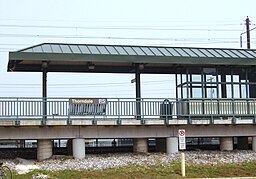
Thorndale SEPTA Station
|
|
| Country | United States |
|---|---|
| State | Pennsylvania |
| County | Chester |
| Township | Caln |
| Elevation | 344 ft (104.9 m) |
| Coordinates | 39°59′47″N 75°45′06″W / 39.99639°N 75.75167°WCoordinates: 39°59′47″N 75°45′06″W / 39.99639°N 75.75167°W |
| Area | 1.8 sq mi (4.7 km2) |
| - land | 1.8 sq mi (5 km2) |
| - water | 0.0 sq mi (0 km2), 0% |
| Population | 3,407 (2010) |
| Density | 1,892.8/sq mi (730.8/km2) |
| Timezone | EST (UTC-5) |
| - summer (DST) | EDT (UTC-4) |
| ZIP code | 19372 |
| Area code | 610 and 484 |
|
Location in Chester County and the state of Pennsylvania.
|
|
|
Location of Pennsylvania in the United States
|
|
Thorndale is a census-designated place (CDP) in Chester County, Pennsylvania, United States. The population was 3,407 at the 2010 census. Thorndale is the commercial and administrative center of Caln Township. The community's main street is Business U.S. Route 30. Many of the old houses that were Thorndale have fallen into disrepair and have been torn down and replaced with new business from the late 1990s to present. Thorndale is historically notable for containing a summer house of US President James Buchanan, which still stands and has been incorporated into a golf course and turned into a restaurant. The community contains the Thorndale Fire Station and Caln Elementary School, part of the Coatesville Area School District. Thorndale sits along SEPTA's Paoli/Thorndale Line and is currently the last station stop on that line. It is also served by the Rover bus system.
Thorndale is located at 39°59′47″N 75°45′6″W / 39.99639°N 75.75167°W (39.996456, -75.751606).
According to the United States Census Bureau, the CDP has a total area of 1.8 square miles (4.7 km2), of which 0.55% is water. It is part of Caln Township, with students attending school in either the Coatesville Area School District or the Downingtown Area School District.
...
Wikipedia


