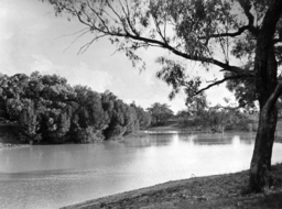
Thomson River, Queensland
| Thomson | |
| River | |
|
Longreach, 1938
|
|
| Name origin: Sir Edward Deas Thomson KCMG, CMG | |
| Country | Australia |
|---|---|
| State | Queensland |
| Regions | Central West Queensland, Western Queensland |
| Part of | Lake Eyre Basin |
| Tributaries | |
| - right | Landsborough Creek, Darr River |
| City | Longreach |
| Source | Alma Range, Great Dividing Range |
| - location | north of Muttaburra |
| - elevation | 215 m (705 ft) |
| Mouth | confluence with the Barcoo River to form Cooper Creek |
| - elevation | 130 m (427 ft) |
| - coordinates | 25°10′2″S 142°53′24″E / 25.16722°S 142.89000°ECoordinates: 25°10′2″S 142°53′24″E / 25.16722°S 142.89000°E |
| Length | 3,500 km (2,175 mi) |
|
Map of the Lake Eyre Basin showing Thomson River
|
|
The Thomson River is a perennial river that forms part of the Lake Eyre Basin, situated in the central west and western regions of Queensland, Australia. Much of the course of the river comprises a series of narrow channels synonymous with the Channel Country and the Gailee subregion.
The river was named in 1847 by the explorer, Edmund Kennedy, in honour of The Hon. Sir Edward Deas Thomson KCMG, CMG, the Colonial Secretary of New South Wales at the time of discovery.
Draining the Alma Range, part of the western slopes of the Great Dividing Range, the northernmost headwaters of the river begin as Torrens Creek, inland from Charters Towers. The watercourse becomes the Thomson just north of the town of Muttaburra, where the channels of Landsborough Creek, Towerhill Creek and Cornish Creek meet. Aramac Creek joins the river from the east, south of Muttaburra and Maneroo Creek flows from the west, joining the Thomson south of Longreach. Just to the west of Longreach the river is crossed by the Landsborough Highway.
...
Wikipedia


