Thiruvambady
|
Thiruvambady തിരുവമ്പാടി |
|
|---|---|
| Town | |

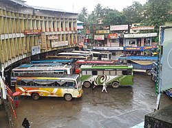
Thiruvambady Bus Stand
|
|
| Location in Kozhikode, Kerala, India | |
| Coordinates: 11°21′39″N 76°00′32″E / 11.36083°N 76.00889°ECoordinates: 11°21′39″N 76°00′32″E / 11.36083°N 76.00889°E | |
| Country |
|
| State | Kerala |
| District | Kozhikode |
| Taluk | Thamarassery |
| Block Panchayat | Koduvally |
| Government | |
| • MP | M.I.Shanavas - Wayanad (Lok Sabha constituency) |
| • MLA | George M Thomas - (Thiruvambady Assembly Constituency) |
| • Panchayath President | P.T Augustin - Thiruvambady Panchayath |
| Population (2011) | |
| • Total | 28,820 |
| Languages | |
| • Official | Malayalam, English |
| Time zone | IST (UTC+5:30) |
| PIN | 673603 |
| Telephone code | 0495 225.... |
| Vehicle registration | KL 57 |
| Sex ratio | 1000:1040 ♂/♀ |
| Literacy | 96% |
Thiruvambady (Malayalam: തിരുവമ്പാടി) is a major hilly town and one of the suburb in the south - eastern side of Kozhikode district in Kerala, India. Thiruvambady is also an Legislative Assembly Constituency which is situated 35 km from Calicut City.
Thiruvambadi is located on the banks of Iruvanjippuzha which is a tributary of Chaliyar situated 35 km far from Kozhikode city. Town is surrounded with mountains, valleys and waterfalls. Famous waterfalls such as Thusharagiri Falls, Arippara Waterfalls, Urumi Hydro Electric Dam Set, Kozhippara Waterfalls Kakkadampoyil, Vellaimala etc.. are situated near to the town.
Thiruvambady is well connected by road network with near by places. A KSRTC Bus Operating Centre is situated in town. There is also a private Bus Stand situated in town. The main Bus Services are to nearby places such as Kozhikode, Mukkam, Omassery, Thamarassery, Koduvally, Pulloorampara, Anakkampoyil, Koodaranji and Kodenchery. Also KSRTC buses operates many inter district services from here.
The Kilometer chart from Thiruvambady is given below:
The early Thiruvambady village was a forest area in Kozhikode taluk from Neeleshwaram to Wayanad ghat. After death of Pazhassi Raja against British Army in 1805 this area belonged to East India Company. In this time the land of Zamorin in Kozhikode also belonged to East India Company. East India Company's Malabar area then after belonged to Madras Presidency and was ruled by British. British divide this whole land to small providences, districts and taluks for the ease of ruling. Like that Thiruvambady area came under Kozhikode Taluk. At that time the domain of land in people living area in Thiruvambady was given to Kottayam King Kalppakassery Karnoru and forest area's domain of land was given to Manniledathu Nair Tharavadu. From this squire (Janmikal) the tenants (Kudiyanmar) got agriculture permission in Thiruvambady. People of Thiruvambady cast their first votes to the Malabar district Board and voting rights were only for those who pay tax. The first man who started business in Thiruvambady was late Kuttiassan belonged to Cheruvadi. The second phase of the history of Thiruvambady begun in the year 1944,due to the immigration of people from Travancore area. Second world war and its aftermath severe poverty led them to immigrates them new pastures. Though there was a school named "Nandanassery school" opportunity only to study up to 4th standard was there. Teachers from distant places stayed in the houses of the landlord and taught. Their salary was a small amount of money and food . A little bit of help was there from the Madras Government there.
...
Wikipedia


