Thermopolis, Wyoming
| Thermopolis, Wyoming | |
|---|---|
| Town | |

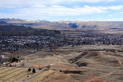
Thermopolis viewed from Roundtop Mountain
|
|
| Nickname(s): "Thermop" "T-Town" | |
| Motto: "A Past To Behold A Future To Uphold" | |
| Location in the United States | |
| Coordinates: 43°38′44″N 108°12′53″W / 43.64556°N 108.21472°WCoordinates: 43°38′44″N 108°12′53″W / 43.64556°N 108.21472°W | |
| Country | United States |
| State | Wyoming |
| County | Hot Springs |
| Government | |
| • Mayor | Michael "Mike" Mortimore |
| • Assistant to the Mayor | Fred Crosby |
| Area | |
| • Total | 2.47 sq mi (6.40 km2) |
| • Land | 2.38 sq mi (6.16 km2) |
| • Water | 0.09 sq mi (0.23 km2) |
| Elevation~±500 feet | 4,331 ft (1,320 m) |
| Population (2010) | |
| • Total | 3,009 |
| • Estimate (2012) | 3,019 |
| • Density | 1,264.3/sq mi (488.1/km2) |
| Time zone | Mountain (MST) (UTC-7) |
| • Summer (DST) | MDT (UTC-6) |
| ZIP code | 82443 |
| Area code(s) | 307 |
| FIPS code | 56-76515 |
| GNIS feature ID | 1597651 |
| Website | www |
Thermopolis is the largest town in, and the county seat of Hot Springs County, Wyoming, United States. As of the 2010 census, the town population was 3,009.
"Thermopolis" (/θɜːrˈmɒpəlɪs/) is from the Greek for "Hot City". It is home to numerous natural hot springs, in which mineral-laden waters are heated by geothermal processes. The town is named for the hot springs located there.
The town claims the world's largest mineral hot spring as part of Hot Springs State Park. The springs are open to the public for free as part of an 1896 treaty signed with the Shoshone and Arapaho Indian tribes.
Thermopolis is also the home of the Wyoming Dinosaur Center, which hosts the only Archaeopteryx fossil outside of Europe.
In 1991, the Associated Press reported, in an article entitled "Hot Springs Rationed: Natural Wonder Drying Up:"
A dramatic decline in the flow of the main spring that feeds the terraces has prompted park management to maintain the water flow to the park's recreation pools and cut off water to half the terraces.
The Big Spring, which pumped 13 million gallons a day in 1896 when the Indians sold the area to the government, now produces mere 3.5 million gallons per day, according to park superintendent Allen Cowardin.
Neither Cowardin nor state water experts know what has caused the reduced flow, nor when it dropped so dramatically...
Thermopolis is located near the northern end of the Wind River Canyon and Wedding of the Waters, where the north-flowing Wind River becomes the Bighorn River. Thermopolis is ringed by mountains, with the Bridger Mountains to the southeast, the Owl Creek Mountains to the southwest, the Big Horn Mountains to the northeast and the Absaroka Range to the northwest. Thermopolis is the southern-most municipality in the Big Horn Basin.
...
Wikipedia

