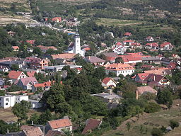
Theben
| Devín | |
| Dévény Theben |
|
| Borough | |
| Country | Slovakia |
|---|---|
| Region | Bratislava |
| District | Bratislava IV |
| River | Danube, Morava |
| Elevation | 125 m (410 ft) |
| Coordinates | 48°10′26″N 16°59′00″E / 48.17389°N 16.98333°ECoordinates: 48°10′26″N 16°59′00″E / 48.17389°N 16.98333°E |
| Area | 13.964 km2 (5.392 sq mi) |
| Population | 1,005 (2005) |
| Density | 72/km2 (186/sq mi) |
| First mentioned | 1237 |
| Postal code | 84105 |
| Area code | +421-02 |
| Car plate | BA, BL |
| Website: Devín | |
| Source | |
Devín (Slovak pronunciation: [ˈɟeʋiːn]; Hungarian: Dévény, German: Theben) is a borough of Bratislava, the capital of Slovakia, located in the Bratislava IV district. Originally a separate village at the confluence of the Danube and Morava rivers, Devín maintained its rural character and today, it is one of the smallest boroughs of Bratislava by population. It is an important archaeological site, featuring the ruins of Devín Castle.
Geographically, Devín lies on the foothills of Devínska Kobyla next to the Devín Gate, a narrow stretch on the river Danube, which was viewed as the western gateway to the Kingdom of Hungary. It lies near the border between Slovakia and Austria which runs down the middle of the Morava and Danube rivers, and which previously formed part of the Iron Curtain between the Eastern and the Western Bloc.
The word Devín stems from the Slovak word deva, which signifies "a girl".
Devín is bordered by Austria from the south and from the west, the borough of Devínska Nová Ves from the north, the borough of Dúbravka from the east and the borough of Karlova Ves from the south-east.
...
Wikipedia


