Karlova Ves
| Karlova Ves | ||
| Borough | ||
|
||
| Country | Slovakia | |
|---|---|---|
| Region | Bratislava | |
| District | Bratislava IV | |
| River | Danube | |
| Elevation | 150 m (492 ft) | |
| Coordinates | 48°09′20″N 17°03′09″E / 48.15556°N 17.05250°ECoordinates: 48°09′20″N 17°03′09″E / 48.15556°N 17.05250°E | |
| Area | 10.948 km2 (4.227 sq mi) | |
| Population | 33,559 (2005) | |
| Density | 3,065/km2 (7,938/sq mi) | |
| First mentioned | 1786 | |
| Postal code | 84105 | |
| Area code | +421-02 | |
| Car plate | BA, BL | |
| Website: www.karlovaves.sk | ||
| Source | ||
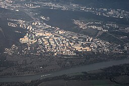
Karlova Ves is a city borough of Bratislava, the capital of Slovakia. It is located in the western part of the city close to the river Danube on the slopes of the Little Carpathians mountains and it is part of the Bratislava IV administrative district. A small, wine-making village for most of its history it was assimilated into Bratislava in the 1940s and in 1957, the construction of a large socialist panelák suburb started. Today, Karlova Ves has approximately 33,000 inhabitants and university dormitories in Mlynská dolina house an additional 15,000 students at the total area of 7874 meters squared.
Karlova Ves consists of three distinct parts: Dlhé diely suburb which houses most of the inhabitants, Mlynská dolina area which features some of the city's central institutions including universities, the Bratislava Zoo and Botanical Garden of the Comenius University. The Karlova Ves proper includes also the largest island in Bratislava; Sihoť. The city part also features the Bratislava Water Museum, the Slávičie údolie cemetery, numerous schools and three Roman-Catholic churches. The St. Francis Square serves as the center of the city borough.
Karlova Ves borders Austria and Petržalka to the south, Devín to the west, Dúbravka to the north and Old Town to the east. The southern boundary is the river Danube. The original village lied on the western slopes of the Bratislava Foothills, the southernmost part of the Devín Carpathians mountain range, in the valley of the Karloveský stream, on both of its sides. The altitude difference is from 134 meters AMSL at the Karloveská bay to 264 m AMSL at the mountain Nad Sitinou, mean altitude in the borough is 165 meters AMSL.
...
Wikipedia


