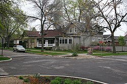
The Villa, Chicago
|
Villa Historic District
|
|

Intersection of Springfield and Waveland Avenues
|
|
| Location | Chicago, Illinois, United States |
|---|---|
| Coordinates | 41°56′56″N 87°43′38″W / 41.94889°N 87.72722°WCoordinates: 41°56′56″N 87°43′38″W / 41.94889°N 87.72722°W |
| Built | 1902; 1913; other |
| Architect | Hatzfeld, Clarence; Knox, Arthur; et al. |
| Architectural style | Bungalow/Craftsman, Other |
| NRHP reference # |
79000830 (original) 83000316 (increase) |
| Significant dates | |
| Added to NRHP | 11 Sep 1979 (original) 10 Mar 1983 (increase) |
| Designated CL | November 23, 1983 |
The Villa District, also known as Villa Historic District, (Polish: Polskie Wille) is a historic district in Chicago, Illinois, United States. It is located on Chicago's Northwest Side within the community area of Irving Park. Its borders are along Pulaski Road to the west, the Union Pacific/Northwest rail line to the north, Hamlin to the east, and Addison Street to the south. Located directly north of the Wacławowo area of Avondale, the Villa District is serviced by the Blue Line's Addison street station.
The district was built in 1902 by a number of architects, many of them visibly influenced by Frank Lloyd Wright's Prairie Style of architecture. Most notable among these were bungalows designed by the architectural firm of Hatzfeld and Knox, whose partner Clarence Hatzfeld would later design the fieldhouse and natatorium at Portage Park. The area was originally developed as the "Villa addition to Irving Park" and showcases many unique Craftsman and Prairie style homes fronting on picturesque boulevard style streets. Although St. Wenceslaus church, a majestic Romanesque-Art Deco hybrid draws many of the tourists visiting the area, this historic church is actually a few blocks south of the district's formal boundaries.
...
Wikipedia

